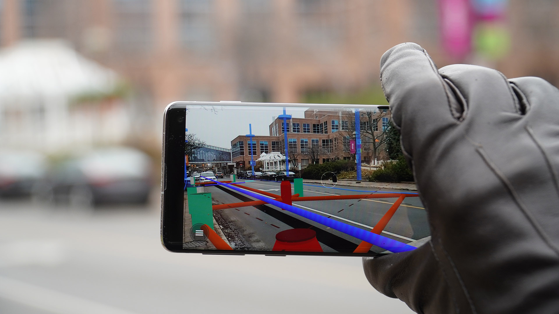
Explore how vGIS is used in your industry. Several factors set vGIS apart from its competition. Cm-accurate augmented reality purpose-built for your job site. Provide easy access to BIM information for everyone at the construction site. Working with our industry partners, vGIS is bringing reality-mesh models into AR. Reality Capture is performed using the vGIS app or a variety of methods offered by vGIS’s partners, and it often requires nothing more than a camera phone to complete.
Canada
Founded in 2014
11-50 Employees
Working industry
IT, Software and Services
Type of company
Manufacturer
Ownership structure
Privately Held
Locations
2 Locations
Number of products
3 Products
Specialised areas
mixed reality, Professional, Scientific, and Technical Services, esri, Internet, Information Technology & Services, augmented reality, construction, exploration, hololens, 3d
vGIS offers a wide range of products and services

Product
vGIS Recognized as a Winner of 2023 Esri's Innovation Award - vGIS - Leading augmented reality solutions for BIM, GIS and 3D scans
Go to product >

Product
vGIS is featured in Esri's ArcNews Magazine - vGIS - Leading augmented reality solutions for BIM, GIS and 3D scans
Go to product >

Product
Ground zero: vGIS technologies help to ‘see’ utilities underground - vGIS - Leading augmented reality solutions for BIM, GIS and 3D scans
Go to product >
An estimation about the ESG values based on digital data and signals. Important: The ESG scores are only based on information about the country, not the actual company itself
Country:
Canada
Overall risk estimation:
Very low
The ESG Data of countries are based on public sources
Environment
A
Grade (A-E)
View details
Social
A
Grade (A-E)
View details
Governance
A
Grade (A-E)
View details
Get insights into the use cases of vGIS

Use case
Google’s “Project Ara” Is Dead; It Was Never Meant To Be - vGIS - Leading augmented reality solutions for BIM, GIS and 3D scans
Last week, Reuters reported the suspension (read “cancellation”) of Google’s plans for a modular smartphone, also known as Project Ara. The project has kept the tech world abuzz for years with the promise of being able to update individual phone components. On the surface, the value proposition of a modular smartphone is tempting – hardware […]

Use case
With AR advancements on mobile devices, is there a practical application for the HoloLens? - vGIS - Leading augmented reality solutions for BIM, GIS and 3D scans
In 2016, a new gadget that was almost unnoticed by the general public set the stage for an arms race in the technology of extended reality (XR). The gadget was the Microsoft HoloLens, a bulky, futuristic-looking headset that finally provided the capabilities that other devices had promised but had so far failed to deliver. Some […]
vGIS operates in 2 countries around the world
Get an overview of the locations of vGIS
Location
Country
State
City
Headquarter
Canada
Ontario
-
vGIS USA Office
United States
Delaware
Wilmington
Some frequent questions that have been asked about vGIS
Where is vGIS located?
The company headquarter of vGIS is located in Ontario, Canada. vGIS has subsidiaries in United States
How many employees does vGIS approximately have?
As of the latest available information vGIS has around 11-50 employees worldwide.
When was vGIS founded?
vGIS was founded in 2014
In which industries does vGIS mainly work?
The company vGIS has it's main focus in the industries of IT, Software and Services
Check out some interesting alternative companies to vGIS
Augview
Waitematā, New Zealand
11-50 Employees
2012
Staff who use Augview are equipped with more than just a GIS or data collection application. With augmented reality, Augview enables less experienced staff to be more aware of the environment they're working in. Utilities use Augview for asset management, increasing and maintaining data accuracy and to assist with communication in the field. The Construction industry uses Augview as an advantage in the tender process by visualising complex 3D architectural models and to give site engineers a tool that will help them plan and manage their site more effectively. Augview is an augmented reality mobile GIS which displays asset data on Android and Apple iOS devices. The three most obvious ways Augview is able to save your company money are: 1. It is a fully functioning mobile GIS allowing users to view maps and edit data and also includes augmented reality visualization tools.
VizAR - Infrastructure Visualisation Platform
Melbourne, Australia
1-10 Employees
2023
VizAR is a Software-as-a-Service (SaaS) platform that incorporates your project data, 3D models and uses augmented reality to easily and accurately visualise infrastructure and construction assets. We also provide professional services to develop new 3D models or provide existing models for wind turbines, solar panels, power lines and other assets from our library. VizAR can publish multiple design changes via simple xml submission to update models, model placement, orientation and geographic location. VizAR is utilised by leading infrastructure and renewable energy providers.
Gosuncn Technology Group Co., Ltd.
Guangzhou City, China
1001-5000 Employees
1997
ARVGIS is a system of software-defined video surveillance platform and device, imple - menting current technology(e.g.artificial intelligence, augmented reality, big data and cloud computing), to provide a complete and objective view of the situation with interaction capabilities. AR —Augmented Reality is the core technology.VGIS— A system that integrates video and multidimensional data, based on the real-time video GIS (Geographic Information System) technology. ARVGIS provides custom development for the 3rd- party system. Focusing on independent innovation and leading the frontier technology, Gosuncn participated in plenty of nation and industry’s standard drafting. Established in 1997, Gosuncn Technology Group Co., Ltd (stock code 300098)has committed to be the world’s leading smart city IoT products and service providers with ‘One horizontal and Four Verticals’ as its strategy, in which One Horizontal includes IoT, big data, and AI (Artificial Intelligence), while the Four Vertical includes public security, transportation, finance, and communication.
AED-SICAD
Bonn, Germany
101-250 Employees
-
VertiGIS creates industry-leading technology that advances spatial visibility into assets – across industries and across the globe. VertiGIS has powerful, trusted tools and viewers that can extend what you’ve built with Esri’s ArcGIS®.
GreenValley International Inc
Berkeley, United States
51-100 Employees
2012
GVI currently offers a wide array of advanced but easy-to-use aerial, terrestrial, and mobile laser scanning technologies. The firm’s extensive product line features multiple high-precision 3D mapping hardware solutions including: LiAir (unmanned aerial vehicle LiDAR), LiBackpack (handheld/mobile LiDAR), LiEagle (fixed-wing/ helicopter LiDAR), and LiMobile (car/truck mounted LiDAR). Along with the cutting-edge hardware product lines, GVI provides versatile software solutions from mission plan (LiPlan) to data acquisition (LiAcquire, LiBackpack Desktop) and from GNSS/IMU data processing (LiNav) to LiDAR georeferencing (LiGeoreference). GVI also provides cloud-based services (LiCloud) for customers easier and better to manage hardware systems and process 3D data. LiDAR360 is a comprehensive point cloud post-processing software that includes a variety of toolsets to efficiently visualize, manipulate and generate meaningful geospatial products from point cloud data. LiPowerline offers an intuitive and highly efficient solution for power line inspection from LiDAR point clouds. LiMapper is a state-of-the-art photogrammetry & computer vision algorithm integrated software designed to generate industry-standard dense cloud, DEM/DSM, and TDOM results. LiDAR360 MLS is a mobile laser scanning(MLS) feature intelligent extraction and analysis software.
GenieVision
Ottignies-Louvain-la-Neuve, Belgium
11-50 Employees
2019
In building construction, your reputation is built on quality and timeliness. GenieVision Augmented Reality (AR) gives engineers and other construction professionals the ability to benchmark on-site reality against the 3D BIM. This innovative IT construction technology detects, corrects, and fixes construction flaws before they become major failures. Making GenieVision part of your BIM project management improves your quality assurance, streamlines your building procedures, and delivers up to 50% savings on costs associated with construction failures. Get your construction professionals everywhere to work smarter, save costs, and deliver on time.