The B2B platform for the best purchasing descision. Identify and compare relevant B2B manufacturers, suppliers and retailers
Close
Filter
Result configuration
Continents
Select continent
Locations
Result types
Company type
Select company type
Industries
Select industry
Company status
Select company status preset
Number of employees
Min.
Max.
Founding year

LiDAR Solutions Australia
Melbourne, Australia
A
1-10 Employees
2019
Key takeaway
LiDAR Solutions, established in 2019 in Melbourne, specializes in providing high-quality LiDAR sensors and solutions that enhance measurement speed and accuracy for various applications, including wind measurement and robotics perception. Their expertise extends to a range of LiDAR products and point cloud processing software, making them a valuable resource for clients in the ANZ region.
Reference
Product
Lidar Surveying Instruments & Products | LiDAR Solutions Australia
Looking for reliable and high-quality Lidar surveying instruments and products? Enquire today and see our range of LiDAR equipment.
MineLiDAR
City of Perth, Australia
A
1-10 Employees
2019
Key takeaway
MINELiDAR is a leading provider of LiDAR scanning services in Australia, utilizing the Emesent Hovermap platform to deliver essential data for informed decision-making across various sectors, including mining and infrastructure.
Reference
Core business
MINELiDAR | Hovermap | LiDAR Scanning Australia
MINELiDAR provides LiDAR scanning services across underground mining, above ground, infrastructure, and data processing and analysis.
Lidiar Group
Greater Brisbane, Australia
A
11-50 Employees
2015
Key takeaway
Lidiar Group offers specialized advisory and technical services tailored to the needs of projects in sectors like energy and infrastructure. Their expertise supports companies in delivering complex solutions and exceeding project objectives.
Reference
Service
Capabilities – Lidiar Group
Looking for more accurate results?
Find the right companies for free by entering your custom query!
25M+ companies
250M+ products
Free to use
Radial Systems
Greater Brisbane, Australia
A
1-10 Employees
2021
Key takeaway
The company specializes in providing fast, accurate, and efficient spatial data capture through advanced airborne scanning and LiDAR measurement. Their services include AI-powered processing and consulting capabilities to support design and analysis for various projects.
Reference
Core business
Radial Systems – Spatial Insights & Intelligence
Bringing your projects fast, accurate and efficient spatial data capture. Using advanced airborne scanning and data processing techniques.
GEOTAUR
City of Perth, Australia
A
11-50 Employees
2016
Key takeaway
Geotaur offers expertise in airborne and mobile laser scanning, including LIDAR data acquisition and feature extraction, which can streamline project processes and enhance spatial data solutions. Their multidisciplinary team is committed to delivering results and innovation, making them a reliable partner for complex tasks.
Reference
Service
Airborne & Mobile Lidar – Geotaur
DroneBelow
Greater Brisbane, Australia
A
1-10 Employees
2016
Key takeaway
The company highlights the significant advancements in drone technology, particularly in relation to LiDAR. This includes Intermap's launch of Lido Surface Data NEXTView for the UAS market and Innoviz's recent funding for LiDAR technology, showcasing its growing importance in various applications.
Reference
Product
LiDAR | Drone Below
Drone Below, Intelligent & Authoritative Drone News

Brisbane Point Cloud
Greater Brisbane, Australia
A
1-10 Employees
2022
Key takeaway
Brisbane Point Cloud specializes in advanced 3D capture services, highlighting LiDAR as an exceptional method for obtaining precise spatial information. Their expertise encompasses various applications, making them a valuable resource for all LiDAR-related needs.
Reference
Core business
Home | Brisbane Pointcloud
Brisbane Pointcloud offers the very best in spatial data capture and processing. From a simple 3D scan to ongoing cloud monitoring, we can help with all your LiDAR needs
Measure Australia
Sydney, Australia
A
11-50 Employees
2014
Key takeaway
Measure Australia utilizes advanced LiDAR laser surveying technology, along with innovative methods like drones and AI/ML, to collect and transform data into valuable insights.
Reference
Service
LiDAR Laser Surveying | Measure Australia
Queensland Drones
Greater Brisbane, Australia
A
1-10 Employees
2015
Key takeaway
Queensland Drones specializes in aerial LiDAR mapping, offering fast and accurate services that include the creation of LiDAR point clouds and topographic maps. Their expertise in this area is highlighted by their work on major projects, such as capturing colorized 3D LiDAR data for a significant arterial road intersection.
Reference
Core business
LIDAR Arterial Road Mapping - Queensland Drones
Queensland Drones was commissioned by a surveying company to capture colourised 3D LIDAR data for a major arterial road intersection and its approaches from
Aerometrex
Adelaide, Australia
A
101-250 Employees
1980
Key takeaway
Aerometrex specializes in high-quality aerial imagery and 3D modeling, highlighting its expertise in LiDAR technology. With a dedicated fleet of aircraft and advanced camera systems, the company is well-equipped to deliver precise aerial mapping solutions.
Reference
Core business
Home- Aerometrex
Technologies which have been searched by others and may be interesting for you:
A selection of suitable products and services provided by verified companies according to your search.

Service
Reality Capture & CAD Services
Go to product
A selection of suitable use cases for products or services provided by verified companies according to your search.

Use case
Reality Capture + Asset Information Modeling
Manufacturing, Factory, Production Plant
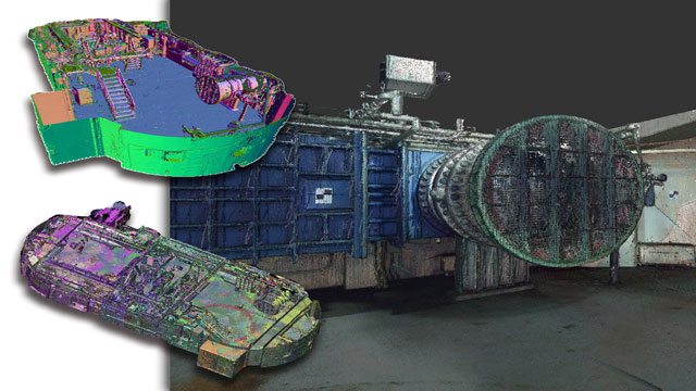
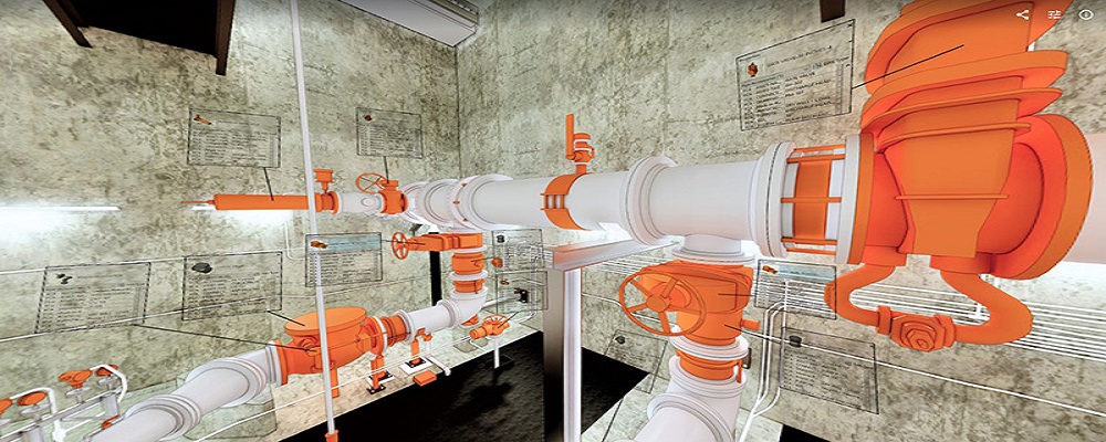
PMI was asked to participate in a pump station renovation in which asset and building life cycle management were high priority. Capturing post demolition conditions with terrestrial laser scanning assisted with the design process, and scanning final construction validated construction, graduating the design documents to as record drawing relevant for management of the building life cycle. The record drawings feature asset data such as model information and serial numbers for major equipment, key information for maintenance and repair.
The LiDAR industry in Australia is characterized by several key considerations for those looking to enter or research companies in this field. Firstly, regulatory frameworks are critical; compliance with Australian laws regarding data collection and environmental assessments is mandatory. The industry faces challenges such as the high costs of technology and the need for skilled personnel, which can limit access for smaller firms. However, opportunities abound due to the increasing demand for high-precision mapping in sectors like agriculture, forestry, and urban planning. Environmental concerns also play a significant role, as LiDAR technology can be used for monitoring ecosystems and managing natural resources responsibly. The competitive landscape includes both local and international players, making it essential to stay informed about advancements and trends. Furthermore, the global market relevance of LiDAR is on the rise, driven by technological advancements and the growing need for accurate spatial data in various applications. Networking within industry groups and attending relevant conferences can provide insights into best practices and emerging technologies, further aiding in informed decision-making for those interested in this dynamic sector.
Some interesting numbers and facts about your company results for LiDAR
| Country with most fitting companies | Australia |
| Amount of fitting manufacturers | 363 |
| Amount of suitable service providers | 382 |
| Average amount of employees | 1-10 |
| Oldest suiting company | 1980 |
| Youngest suiting company | 2022 |
Some interesting questions that has been asked about the results you have just received for LiDAR
What are related technologies to LiDAR?
Based on our calculations related technologies to LiDAR are Magnets, Printed Electronics, Industrial Amplifiers, Electronic Transducers, Electronic Oscillators
Who are Start-Ups in the field of LiDAR?
Start-Ups who are working in LiDAR are Radial Systems, Brisbane Point Cloud
Which industries are mostly working on LiDAR?
The most represented industries which are working in LiDAR are IT, Software and Services, Other, Construction, Aviation and Aerospace, Electronics and Electrical engineering
How does ensun find these LiDAR Companies?
ensun uses an advanced search and ranking system capable of sifting through millions of companies and hundreds of millions of products and services to identify suitable matches. This is achieved by leveraging cutting-edge technologies, including Artificial Intelligence.