Locations
Company type
Result types
Industries
Employees
Founding year

The B2B platform for the best purchasing descision. Identify and compare relevant B2B manufacturers, suppliers and retailers
Close
Filter
Result configuration
Continents
Select continent
Locations
Result types
Company type
Select company type
Industries
Select industry
Company status
Select company status preset
Number of employees
Min.
Max.
Founding year
Goodland Surveys Private Limited
Chennai, India
D
251-500 Employees
2003
Key takeaway
The company specializes in various LiDAR services, including Mobile LiDAR and Aerial LiDAR Survey, as well as data processing and mapping. They are recognized as a nationwide leader in LiDAR and engineering surveying, utilizing the latest technologies to deliver accurate results for their clients.
Reference
Core business
Lidar Survey – My Blog
GeoCentroid Pvt. Ltd
Bengaluru, India
D
11-50 Employees
2016
Key takeaway
GeoCentroid Private Limited specializes in LiDAR mapping and offers comprehensive services related to data processing, classification, and mapping. Their expertise includes producing "As built" BIM-ready 3D models from high-resolution point clouds collected via static or mobile LiDAR.
Reference
Service
Lidar Service Providers | Lidar Engineering - Geocentroid
ORBX TECHNOLOGIES PRIVATE LIMITED
India
D
1-10 Employees
2020
Key takeaway
ORBX Technologies specializes in LiDAR data processing, which is a key remote sensing method for examining the Earth's surface. They emphasize delivering high-quality, customized data solutions to meet client needs efficiently.
Reference
Service
Services - Orbx Technologies
Services LIDAR DATA PROCESSING ORTHOPHOTO PROCESSING PHOTOGRAMMETRY
Looking for more accurate results?
Find the right companies for free by entering your custom query!
25M+ companies
250M+ products
Free to use
KGLOBE SOFTTECH INDIA PVT LTD
India
D
11-50 Employees
2020
Key takeaway
KGLOBE SOFTTECH INDIA PRIVATE LIMITED offers comprehensive LiDAR services that measure distance to targets using laser light and sensor technology. Their expertise extends across various industries, ensuring high quality and professionalism from initial stages to final implementation.
Reference
Core business
KGLOBE SOFTTECH INDIA PRIVATE LIMITED
Ansimap Technologies
New Delhi, India
D
11-50 Employees
-
Key takeaway
Ansimap provides advanced BIM services to the architecture, engineering, and construction (AEC) industry, which includes solutions like Scan to BIM that can utilize LiDAR technology for enhanced geographic data analysis and visualization. Their expertise in UAV services also supports applications such as surveying and mapping.
Reference
Service
Ansimap Technologies || Home
Eastern Aero Carto Pvt Ltd. (EACPL)
Hyderabad, India
D
11-50 Employees
1988
Key takeaway
EACPL is involved in the production of LiDAR data products, highlighting their expertise in geospatial projects and commitment to delivering quality solutions to clients.
Reference
Product
LiDAR Data Products – EACPL
Production Modeling India Pvt. Ltd.
India
D
101-250 Employees
2006
Key takeaway
PMI (Production Modeling India) offers LiDAR mapping services, highlighting its commitment to providing advanced engineering solutions. With over 32 years of experience in operations improvement across various sectors, PMI is well-equipped to deliver high ROI solutions, including innovative mapping technologies.
Reference
Service
LiDAR Mapping Services - PMI
Innovative Geospatial Solutions LLP
New Delhi, India
D
1-10 Employees
2021
Key takeaway
SatLab Geosolutions AB specializes in advanced LiDAR technologies, notably the Lixel X1 Handheld SLAM Scanner, which enables real-time 3D reconstruction and colorized point cloud generation. Their commitment to innovation and quality ensures that their LiDAR solutions effectively support industries such as civil engineering, construction, and more.
Reference
Product
Lixel X1 Handheld SLAM Scanner | Global Satellite Positioning Solutions | SatLab Geosolutions AB
HDSENSE
Bengaluru, India
D
51-100 Employees
2017
Key takeaway
HDSENSE is a next-generation geospatial firm that specializes in collecting and analyzing geospatial data, offering comprehensive production services in LiDAR and remote sensing. Their expertise in using advanced techniques to process near-real-time data from various platforms positions them as a key player in the field.
Reference
Core business
High Definition Mapping Services | Bengaluru | Hdsense
HDSENSE is a Next Generation Geospatial Services firm with Unique Industry Experience to Collect, Collate, Process and Analyse Spatial Data.
JKR CONSULTING & SERVICES
Bhubaneswar Municipal Corporation, India
D
11-50 Employees
2019
Key takeaway
JKR Consulting & Services offers a comprehensive range of Geospatial and Engineering Solutions, including Light Detection and Ranging (LiDAR). Their expertise and state-of-the-art infrastructure ensure that clients receive customized solutions that enhance business performance and increase revenue.
Reference
Service
Light Detection and Ranging (LIDAR) - JKR
Construction consultants provide expert proactive and forensic support for construction projects and construction claims.
Technologies which have been searched by others and may be interesting for you:
A selection of suitable products and services provided by verified companies according to your search.
Service
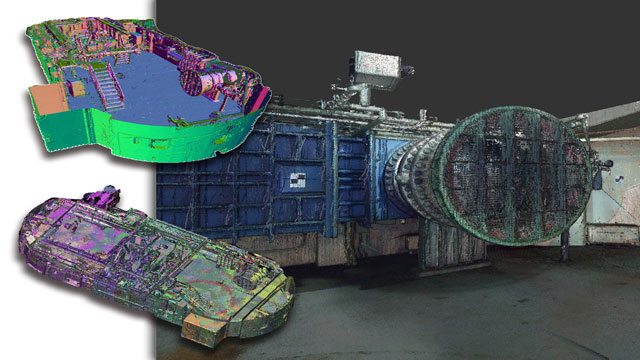
Reality Capture & CAD Services
Go to product
A selection of suitable use cases for products or services provided by verified companies according to your search.
Use case
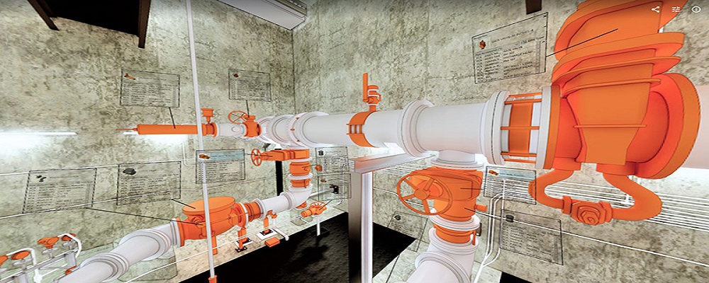
Reality Capture + Asset Information Modeling
Manufacturing, Factory, Production Plant
PMI was asked to participate in a pump station renovation in which asset and building life cycle management were high priority. Capturing post demolition conditions with terrestrial laser scanning assisted with the design process, and scanning final construction validated construction, graduating the design documents to as record drawing relevant for management of the building life cycle. The record drawings feature asset data such as model information and serial numbers for major equipment, key information for maintenance and repair.
Use case
Reality Capture + Asset Information Modeling
Manufacturing, Factory, Production Plant
PMI was asked to participate in a pump station renovation in which asset and building life cycle management were high priority. Capturing post demolition conditions with terrestrial laser scanning assisted with the design process, and scanning final construction validated construction, graduating the design documents to as record drawing relevant for management of the building life cycle. The record drawings feature asset data such as model information and serial numbers for major equipment, key information for maintenance and repair.
When exploring the LiDAR industry in India, several key considerations are essential. Regulatory frameworks governing data collection and use are crucial, as they influence compliance and operational capabilities. The Indian government is increasingly focusing on infrastructure development, which presents opportunities for LiDAR applications in urban planning, agriculture, and environmental monitoring. However, challenges such as high initial costs, technical expertise, and limited awareness about LiDAR technology may hinder adoption. Environmental concerns also play a significant role, as sustainable practices must be integrated into LiDAR operations to minimize ecological impacts. The competitive landscape is evolving, with both domestic and international companies vying for market share, making it important to assess their technological capabilities and service offerings. Additionally, India's position in the global LiDAR market is growing, driven by advancements in technology and increasing demand for high-resolution mapping solutions. Investors and stakeholders should also consider collaboration opportunities with research institutions and governmental bodies, as these partnerships can foster innovation and enhance project outcomes. Keeping abreast of global trends and local developments will be vital for anyone looking to enter or expand within the LiDAR sector in India.
Some interesting numbers and facts about your company results for LiDAR
| Country with most fitting companies | India |
| Amount of fitting manufacturers | 305 |
| Amount of suitable service providers | 282 |
| Average amount of employees | 11-50 |
| Oldest suiting company | 1988 |
| Youngest suiting company | 2021 |
Some interesting questions that has been asked about the results you have just received for LiDAR
What are related technologies to LiDAR?
Based on our calculations related technologies to LiDAR are Magnets, Printed Electronics, Industrial Amplifiers, Electronic Transducers, Electronic Oscillators
Who are Start-Ups in the field of LiDAR?
Start-Ups who are working in LiDAR are Innovative Geospatial Solutions LLP
Which industries are mostly working on LiDAR?
The most represented industries which are working in LiDAR are IT, Software and Services, Aviation and Aerospace, Construction, Marketing Services, Electronics and Electrical engineering
How does ensun find these LiDAR Companies?
ensun uses an advanced search and ranking system capable of sifting through millions of companies and hundreds of millions of products and services to identify suitable matches. This is achieved by leveraging cutting-edge technologies, including Artificial Intelligence.