Locations
Company type
Result types
Industries
Employees
Founding year

The B2B platform for the best purchasing descision. Identify and compare relevant B2B manufacturers, suppliers and retailers
Close
Filter
Result configuration
Continents
Select continent
Locations
Result types
Company type
Select company type
Industries
Select industry
Company status
Select company status preset
Number of employees
Min.
Max.
Founding year
NABLA VISION
Gavà, Spain
A
1-10 Employees
-
Key takeaway
The company specializes in enhancing 3D perception systems by integrating cost-efficient LiDAR and camera devices, providing accurate and relevant vision data for AI applications. Their focus on adapting and fusing LiDAR technology for various demanding sectors supports the development of solutions for mobility, safety, automation, and more.
Reference
Core business
HOME | Nablavision
Transformando el LiDAR y la Percepción. Aportamos información visual precisa y con datos altamente relevantes para aplicaciones de percepción 3D mejoradas mediante inteligencia artificial
Ommatidia LIDAR
Madrid, Spain
A
1-10 Employees
2018
Key takeaway
The company utilizes innovative technology that mimics bees to enhance LIDAR performance, offering products that capture detailed 3D point clouds and enable real-time data acquisition for applications in manufacturing, logistics, and transport. Their Q series products are specifically designed to recover high-quality data from large structures.
Reference
Core business
About Us - Ommatidia LiDAR
AEROLASER SYSTEM SL
Las Palmas de Gran Canaria, Spain
A
11-50 Employees
2008
Key takeaway
The company, Aerolaser System S.L., has developed advanced LiDAR and photogrammetry technology, offering competitive geospatial solutions that include the capture of point clouds and the integration of LiDAR with RGB imagery for comprehensive corridor mapping and anomaly detection.
Reference
Core business
Aerolaser System S.L. Tecnología LiDAR y fotogramétrica avanzada
Looking for more accurate results?
Find the right companies for free by entering your custom query!
25M+ companies
250M+ products
Free to use
TRACK Surveying Solutions
Madrid, Spain
A
1-10 Employees
2012
Key takeaway
The Velodyne Puck LiDAR sensor is highlighted as a market leader, with the Puck Hi-Res variant designed for applications needing higher image resolution.
Reference
Core business
Track Surveying | Distribuidores oficiales de Velodyne Lidar

Worlding Seven
Mérida, Spain
A
11-50 Employees
2012
Key takeaway
Servitopo specializes in topography and engineering services, offering advanced LiDAR solutions like the mdLiDAR1000HR, which provides high-resolution point clouds for detailed terrain analysis. Their expertise in creating topographic maps and assessing geological features can greatly benefit urban planning and agricultural decisions.
Reference
Product
mdLiDAR1000HR - Servitopo
mdLiDAR1000HR: HR implica obtener nubes de puntos de alta resolución y mayor cobertura de forma más sencilla y accesible que nunca. Este es el UAV, hardware, software, flujo de trabajo, entrenamiento y soporte que necesitan los profesionales de la topografía. ESPECIFICACIONES BÁSICAS Precisión del sistema Nube de puntos LiDAR 4 cm RMSE Fotogrametría: Horizontal: 1 – 2 pixels Vertical: 3 – 4 pixels Sensor: Velodyne PUCK VLP-16 MÁS INFORMACIÓN
ATLAS Innovative Engineering
Valladolid, Spain
A
11-50 Employees
2014
Key takeaway
The company specializes in high-precision forest inventory using airborne LiDAR data, which enhances risk management and operational efficiency. Their innovative digital solutions contribute to environmental care and safety in operations, making them relevant for industries that rely on accurate data for sustainability and risk assessment.
Reference
Core business
Atlas
Aerial_Insights
Spain
A
1-10 Employees
2015
Key takeaway
Aerial Insights offers advanced drone imaging processing technology, enabling efficient and cost-effective drone-based topography. Their online platform allows users to easily upload and process aerial images to generate accurate georeferenced models.
Reference
Core business
Topografía con drones - Procesa tus imágenes de forma sencilla y económica
Procesa las imágenes de tus levantamientos topográficos con drone de forma sencilla y económica a través de nuestra plataforma online - Pago por uso
Terrain Technologies
Gijón, Spain
A
11-50 Employees
2003
Key takeaway
Terrain Technologies specializes in GIS consultancy and spatial data management, offering innovative solutions across various sectors. They also distribute Skyline Software Systems, which provides advanced 3D earth visualization tools that could be relevant for LiDAR applications in emergency management and infrastructure development.
Reference
Core business
Terrain Technologies
Acero Estudio
Paterna, Spain
A
11-50 Employees
1998
Key takeaway
The company, Acero Estudio, specializes in LiDAR services, along with other technologies such as 3D laser scanning and drone photogrammetry, making it a key resource for engineering firms, architects, and construction companies.
Reference
Core business
Topografía - Consultoría BIM - Fotogrametría - LIDAR - Acero Estudio
Acero Estudio es especialista en servicios topográficos, consultoría BIM, fotogrametría con drones, LIDAR y Láser Escáner 3D
ScanPhase - 3D scanning and reproduction services with laser scanner
Esplugues de Llobregat, Spain
A
11-50 Employees
2015
Key takeaway
Scanphase España is a company that specializes in 3D Laser Scanning or LiDAR (Laser Imaging Detection and Ranging), focusing on the rapid and precise capture of geo-spatial information to produce detailed and informative 3D BIM models from point cloud data. Their expertise in scanning technologies enables them to create accurate representations of both small elements and large infrastructures, making their services valuable for various applications, including architecture and engineering.
Reference
Core business
Escaneo láser 3D España | Escaneado láser | Nubes de puntos | BIM | Scan to BIM
Empresa de servicios de escaneo láser 3D en España mediante escáner láser. Servicios de escaneado láser 3D, generación de nubes de puntos, Ingeniería inversa y escaneado de todo tipo de elementos e infraestructuras (Reality Capture) para arquitectura (BIM), ingeniería, industria, patrimonio. Barcelona
Technologies which have been searched by others and may be interesting for you:
A selection of suitable products and services provided by verified companies according to your search.
Service
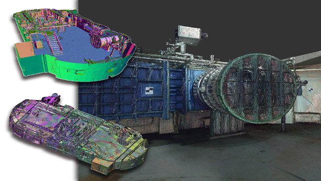
Reality Capture & CAD Services
Go to product
A selection of suitable use cases for products or services provided by verified companies according to your search.
Use case
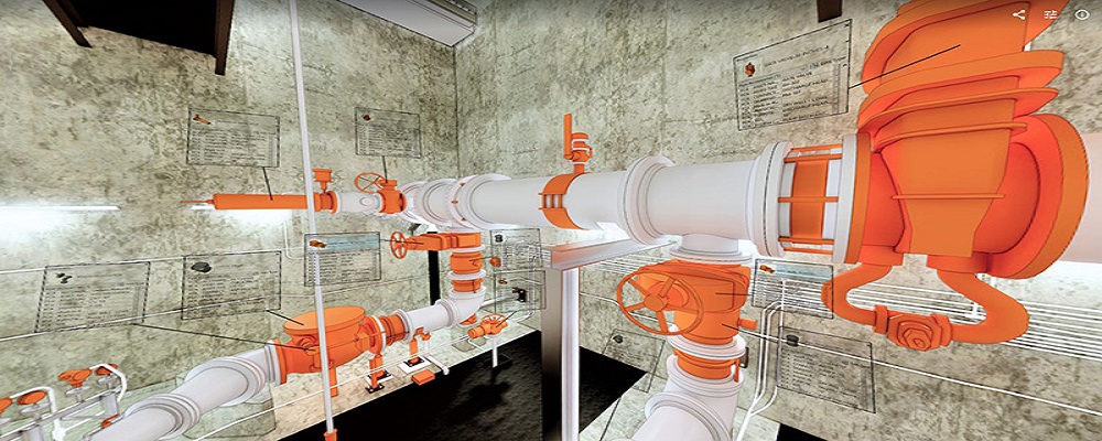
Reality Capture + Asset Information Modeling
Manufacturing, Factory, Production Plant
PMI was asked to participate in a pump station renovation in which asset and building life cycle management were high priority. Capturing post demolition conditions with terrestrial laser scanning assisted with the design process, and scanning final construction validated construction, graduating the design documents to as record drawing relevant for management of the building life cycle. The record drawings feature asset data such as model information and serial numbers for major equipment, key information for maintenance and repair.
Use case
Reality Capture + Asset Information Modeling
Manufacturing, Factory, Production Plant
PMI was asked to participate in a pump station renovation in which asset and building life cycle management were high priority. Capturing post demolition conditions with terrestrial laser scanning assisted with the design process, and scanning final construction validated construction, graduating the design documents to as record drawing relevant for management of the building life cycle. The record drawings feature asset data such as model information and serial numbers for major equipment, key information for maintenance and repair.
The LiDAR industry in Spain presents several key considerations for those interested in this technology. First, understanding the regulatory landscape is crucial, as compliance with European Union guidelines and local laws can impact operations significantly. There are opportunities in sectors such as agriculture, forestry, urban planning, and infrastructure development, where LiDAR technology can enhance precision and efficiency. Environmental concerns are also pertinent, as sustainable practices are increasingly demanded by both the government and consumers, which can shape project viability. The competitive landscape includes both established companies and emerging startups, creating a dynamic environment where innovation is key. It is essential to evaluate the technological capabilities and service offerings of different firms, as advancements in drone-based LiDAR and mobile mapping systems are transforming the industry. Additionally, the global market relevance of LiDAR technology suggests that Spain’s position can attract international partnerships and investment, enhancing its competitiveness. Understanding the challenges, such as high initial costs and data processing complexities, is vital for making informed decisions. Overall, a thorough research approach focusing on these factors can provide valuable insight into the potential and direction of the LiDAR industry in Spain.
Some interesting numbers and facts about your company results for LiDAR
| Country with most fitting companies | Spain |
| Amount of fitting manufacturers | 172 |
| Amount of suitable service providers | 116 |
| Average amount of employees | 11-50 |
| Oldest suiting company | 1998 |
| Youngest suiting company | 2018 |
Some interesting questions that has been asked about the results you have just received for LiDAR
What are related technologies to LiDAR?
Based on our calculations related technologies to LiDAR are Magnets, Printed Electronics, Industrial Amplifiers, Electronic Transducers, Electronic Oscillators
Which industries are mostly working on LiDAR?
The most represented industries which are working in LiDAR are IT, Software and Services, Construction, Aviation and Aerospace, Other, Manufacturing
How does ensun find these LiDAR Companies?
ensun uses an advanced search and ranking system capable of sifting through millions of companies and hundreds of millions of products and services to identify suitable matches. This is achieved by leveraging cutting-edge technologies, including Artificial Intelligence.