Locations
Company type
Result types
Industries
Employees
Founding year

The B2B platform for the best purchasing descision. Identify and compare relevant B2B manufacturers, suppliers and retailers
Close
Filter
Result configuration
Continents
Select continent
Locations
Result types
Company type
Select company type
Industries
Select industry
Company status
Select company status preset
Number of employees
Min.
Max.
Founding year
LIDAR ITALIA
Genoa, Italy
B
1-10 Employees
2019
Key takeaway
The company specializes in LiDAR technology, offering high-precision sensors that emit laser beams to detect thousands of points per second, which is essential for accurate and comprehensive surveying. Their products and expertise enable professionals to effectively utilize LiDAR for various applications, including monitoring unstable slopes.
Reference
Core business
La nuova frontiera del rilievo 3D. LIDAR da drone e da terra - Lidar Italia
Lidar-italia fornisce prodotti e competenze per progettare ed elaborare rilievi LIDAR. Rivendita hardware e software, assistenza e formazione. Scopri di più
SCANFLY
Italy
B
11-50 Employees
2008
Key takeaway
Scanfly has released several advanced LiDAR products, including the Scanfly XT with a Hesai LiDAR sensor and the innovative SmartProcessing Lidar technology. Their new offerings, such as the Scanfly Duo and Scanfly EVO & PRO, enhance the capabilities of capturing reality, making them valuable tools for various applications.
Reference
Product
Smart Processing Lidar – 3DT Scanfly – The payload lidar not only for UAS
Flyted
Sesto San Giovanni, Italy
B
11-50 Employees
2020
Key takeaway
Flyted utilizes UAS and precision surveying sensors to conduct surveys for design, construction, and maintenance in various sectors. Notably, the company employs LiDAR technology to create Digital Twins and offers solutions for complex data recording.
Reference
Product
LiDAR, Photogrammetry, Inspections and TED - Flyted products
Flyted realizes Digital Twin with LiDAR or Photogrammetry and Photographic inspections. TED is an Information Management platform.
Looking for more accurate results?
Find the right companies for free by entering your custom query!
25M+ companies
250M+ products
Free to use

TIDALIS Aero
Italy
B
1-10 Employees
2008
Key takeaway
Tidalis srl specializes in LiDAR mapping using UAVs and helicopters, particularly over large areas and steep terrains. With extensive experience in aerial surveying, Tidalis is committed to precision and innovation in the field of photogrammetry and LiDAR applications.
Reference
Product
Tidalis - Leaders in Fotogrammetria Aerea Laserscanning Ispezioni Riprese Aeree Emergenze
Lanp Srl
Italy
B
11-50 Employees
2018
Key takeaway
Ulisse is revolutionizing the understanding of physical spaces by integrating advanced LiDAR and Radar technologies into their innovative IoT platform, Clic-Clac. Their solutions enhance perception and data-driven decision-making, transforming spatial inefficiencies into profitable opportunities.
Reference
Product
Technology | Ulisse, physical places analytics
Alto Drones
Eppan an der Weinstraße - Appiano sulla Strada del Vino, Italy
B
1-10 Employees
-
Key takeaway
The company offers professional surveying and technical inspection services, including advanced LiDAR capabilities with their latest laser scanner, the RIEGL VQ-840-G.
Reference
Core business
Home | Alto Drones
IDS GeoRadar
Ospedaletto, Italy
B
101-250 Employees
1980
Key takeaway
IDS GeoRadar offers advanced products and solutions that could be relevant for applications in geophysical and civil engineering fields. Their focus on digitizing the unseeable suggests potential capabilities in remote sensing technologies like LiDAR.
Reference
Product
Software | IDS GeoRadar
Digitising the unseeable easily, safely and accurately.
Photogram GmbH Srl
Vahrn - Varna, Italy
B
1-10 Employees
2017
Key takeaway
Photogram.pro is an automated online platform that uses photogrammetry to create georeferenced 3D models from videos and photos, highlighting its capabilities in infrastructure and construction. The company's emphasis on advanced technologies like cloud computing and machine learning suggests a commitment to innovative solutions in 3D modeling.
Reference
Product
PhotoScan
Online photogrammetry solution
LIGHTHOUSE GEO
Zola Predosa, Italy
B
51-100 Employees
1986
Key takeaway
Lighthouse offers precise positioning and construction support services to telecommunications companies, which is essential for infrastructure planning and design. With a strong reputation for reliability and expertise since its founding in 1986, the company ensures that all projects are executed with a commitment to quality and efficiency.
Reference
Service
Positioning and Construction Support - Lighthouse
High cost construction operations demand highly accurate positioning, fast service and rapid decision-making. Lighthouse provides solutions worldwide.
AEMME SURVEYING part of AEMME RE S.r.l.
Turin, Italy
B
1-10 Employees
2005
Key takeaway
YellowScan is a leading company in the design and production of LiDAR systems for drones, offering a wide range of precise and reliable aerial mapping solutions, complemented by proprietary software for an efficient workflow.
Reference
Product
Software - Aemme Surveying
Technologies which have been searched by others and may be interesting for you:
A selection of suitable products and services provided by verified companies according to your search.
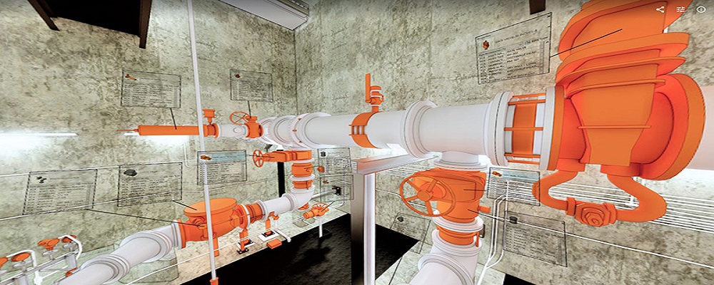
Service
Reality Capture & CAD Services
Go to product
A selection of suitable use cases for products or services provided by verified companies according to your search.
Use case
Reality Capture + Asset Information Modeling
Manufacturing, Factory, Production Plant
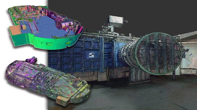
PMI was asked to participate in a pump station renovation in which asset and building life cycle management were high priority. Capturing post demolition conditions with terrestrial laser scanning assisted with the design process, and scanning final construction validated construction, graduating the design documents to as record drawing relevant for management of the building life cycle. The record drawings feature asset data such as model information and serial numbers for major equipment, key information for maintenance and repair.
Use case
Reality Capture + Asset Information Modeling
Manufacturing, Factory, Production Plant
PMI was asked to participate in a pump station renovation in which asset and building life cycle management were high priority. Capturing post demolition conditions with terrestrial laser scanning assisted with the design process, and scanning final construction validated construction, graduating the design documents to as record drawing relevant for management of the building life cycle. The record drawings feature asset data such as model information and serial numbers for major equipment, key information for maintenance and repair.
In the LiDAR industry in Italy, several key considerations are essential for informed decision-making. First, understanding the regulatory framework is crucial, as compliance with European Union directives and national standards can impact operations. Italy's rich cultural heritage and diverse landscapes present unique opportunities for LiDAR applications in archaeology, urban planning, and environmental monitoring, making it a vibrant market for innovation. However, challenges such as high competition among local and international firms exist, pushing companies to differentiate through technology or specialized services. The environmental concerns associated with land surveying and data collection also require companies to adopt sustainable practices to mitigate ecological impacts. Furthermore, the global market relevance of LiDAR technology continues to grow, driven by advancements in autonomous systems and smart cities, positioning Italy as a competitive player on the international stage. Networking within industry associations and attending relevant trade shows can provide valuable insights and foster partnerships, essential for anyone looking to navigate this evolving landscape effectively.
Some interesting numbers and facts about your company results for LiDAR
| Country with most fitting companies | Italy |
| Amount of fitting manufacturers | 153 |
| Amount of suitable service providers | 111 |
| Average amount of employees | 11-50 |
| Oldest suiting company | 1980 |
| Youngest suiting company | 2020 |
Some interesting questions that has been asked about the results you have just received for LiDAR
What are related technologies to LiDAR?
Based on our calculations related technologies to LiDAR are Magnets, Printed Electronics, Industrial Amplifiers, Electronic Transducers, Electronic Oscillators
Which industries are mostly working on LiDAR?
The most represented industries which are working in LiDAR are IT, Software and Services, Other, Electronics and Electrical engineering, Aviation and Aerospace, Construction
How does ensun find these LiDAR Companies?
ensun uses an advanced search and ranking system capable of sifting through millions of companies and hundreds of millions of products and services to identify suitable matches. This is achieved by leveraging cutting-edge technologies, including Artificial Intelligence.