Locations
Company type
Result types
Industries
Employees
Founding year

The B2B platform for the best purchasing descision. Identify and compare relevant B2B manufacturers, suppliers and retailers
Close
Filter
Result configuration
Continents
Select continent
Locations
Result types
Company type
Select company type
Industries
Select industry
Company status
Select company status preset
Number of employees
Min.
Max.
Founding year
Litum
Turkey
C
51-100 Employees
2004
Key takeaway
Litum specializes in enhancing operations through location intelligence, offering real-time location solutions that ensure sub-meter accuracy using UWB technology. Their innovative approach is transforming safety and efficiency in various sectors, demonstrating the potential of advanced tracking systems.
Reference
Core business
Litum RTLS - Indoor Tracking Services - Real Time Location
Real-time visibility of your employees and equipment for enhanced safety, security and efficiency. Litum UWB RTLS technology for precise indoor tracking.
Surveying Group
Kadıköy, Turkey
C
1-10 Employees
2017
Key takeaway
SurveyingGroup provides comprehensive coverage of the geospatial industry, including in-depth insights on LiDAR technology and its applications in surveying and mapping. Their commitment to delivering the latest news and trends makes them a valuable resource for those interested in advancements in LiDAR and related fields.
Reference
Core business
SGN - Latest Geospatial News
Surveyinggroup is dedicated to producing the latest industrial news, the best guides, and how-tos about the Surveying, GIS-Mapping, Lidar, and Photogrammetry.
SKYSENS
Şişli, Turkey
C
11-50 Employees
2015
Key takeaway
Skysens offers advanced industrial data solutions that could enhance the integration of LiDAR data into predictive maintenance frameworks. Their platform provides long-range wireless capabilities and data analytics, which are essential for optimizing asset performance and energy efficiency in industrial applications.
Reference
Core business
Company – Skysens
Looking for more accurate results?
Find the right companies for free by entering your custom query!
25M+ companies
250M+ products
Free to use
Arventek Technology
Pendik, Turkey
C
1-10 Employees
2020
Key takeaway
Arventek is a construction technology company that enhances project management and accelerates infrastructure delivery through its RemoteSite platform, which leverages advanced data analytics and drone-based data collection. Their focus on innovation and digital transformation in asset-heavy industries like construction, mining, and energy aligns with the growing importance of technologies such as LiDAR in improving operational efficiency and project tracking.
Reference
Core business
Arventek – Gaze the Future from the Skies!
Enveko Teknoloji
Turkey
C
1-10 Employees
-
Key takeaway
The company specializes in developing custom products and solutions that enhance site inspections and analysis, particularly through 3D modeling and reconstruction using UAVs and UGVs. Their focus on autonomous control and vision solutions could be relevant for applications like digital twins and environmental monitoring.
Reference
Core business
Enveko Teknoloji
UAV and UGV focused autonomous control and vision solutions for all your mobile vision needs ranging from site inspection to agriculture.
Sur Harita
Sultanbeyli, Turkey
C
1-10 Employees
2017
Key takeaway
Sur Harita ve Mühendislik Hizmetleri Şirketi specializes in high-precision measurements and offers 3D Laser Scanning, also known as LiDAR, which involves sending laser beams to collect three-dimensional data without the use of reflectors.
Reference
Service
3D Lazer Tarama | Sur Harita & Mühendislik
3D Lazer Tarama veya LIDAR, 3 boyutlu veri toplamak için bir yüzey üzerine yansıtıcı kullanmadan lazer ışını gönderme işlemidir
UAS Engineering
Ataşehir, Turkey
C
1-10 Employees
2021
Key takeaway
UAS Engineering is a leading service provider and authorized dealer of unmanned aerial vehicles, which may include applications relevant to LiDAR technology, particularly in drone inspection services.
Reference
Core business
uas engineering
ART Labs
Turkey
C
11-50 Employees
2019
Key takeaway
The company specializes in creating immersive 3D and augmented reality experiences that enhance eCommerce performance and customer engagement. Their solutions include virtual try-on and interactive 3D assets, which can be particularly useful for bridging the gap between physical and digital shopping.
Reference
Core business
artlabs | Scaling 3D with AI and Enabling AR Experiences for Brands and Creators
ArgosAI
Turkey
C
11-50 Employees
2015
Key takeaway
ArgosAI develops advanced technologies, including computer vision and artificial intelligence, to enhance airport ground operations. Their focus on automating processes and continuously monitoring conditions aims to improve safety and efficiency in airside operations.
Reference
Product
Technology - ArgosAI
ArgosAI’s portfolio of solutions enables airports to accelerate their digital transformation as they manage one of the world’s most complex and safety-critical operations.
Lumnion
Sarıyer, Turkey
C
11-50 Employees
2017
Key takeaway
Lumnion's platform supports various machine learning algorithms for risk modeling, enhancing transparency and usability of results, which could be relevant for those exploring applications of LiDAR data in risk assessment.
Reference
Core business
Lumnion
Al based Insurance Pricing Platform
Technologies which have been searched by others and may be interesting for you:
A selection of suitable products and services provided by verified companies according to your search.
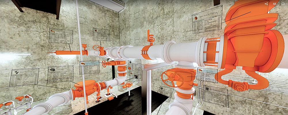
Service
Reality Capture & CAD Services
Go to product
A selection of suitable use cases for products or services provided by verified companies according to your search.
Use case
Reality Capture + Asset Information Modeling
Manufacturing, Factory, Production Plant
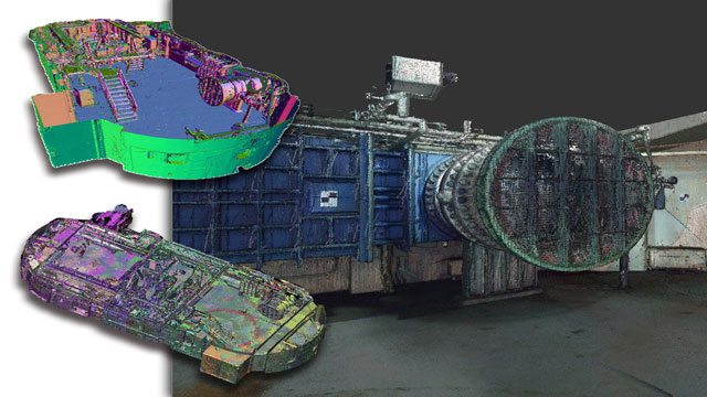
PMI was asked to participate in a pump station renovation in which asset and building life cycle management were high priority. Capturing post demolition conditions with terrestrial laser scanning assisted with the design process, and scanning final construction validated construction, graduating the design documents to as record drawing relevant for management of the building life cycle. The record drawings feature asset data such as model information and serial numbers for major equipment, key information for maintenance and repair.
Use case
Reality Capture + Asset Information Modeling
Manufacturing, Factory, Production Plant
PMI was asked to participate in a pump station renovation in which asset and building life cycle management were high priority. Capturing post demolition conditions with terrestrial laser scanning assisted with the design process, and scanning final construction validated construction, graduating the design documents to as record drawing relevant for management of the building life cycle. The record drawings feature asset data such as model information and serial numbers for major equipment, key information for maintenance and repair.
When delving into the LiDAR industry in Turkey, several key considerations come into play. First, understanding the regulatory landscape is crucial, as Turkey has specific laws governing aerial surveys and remote sensing technologies. Compliance with these regulations ensures that companies operate legally and efficiently. Additionally, the competitive landscape features both established firms and emerging startups, driving innovation and offering diverse solutions in various sectors such as agriculture, forestry, and urban planning. Opportunities in the Turkish LiDAR market are expanding, particularly due to increasing investments in infrastructure projects and urban development initiatives. These projects often require precise mapping and data collection, where LiDAR technology excels. However, challenges such as limited local expertise and the need for advanced training programs can hinder growth. Environmental considerations are also significant, as the use of LiDAR must align with sustainable practices to minimize ecological impact. Globally, the relevance of the Turkish LiDAR industry is underscored by Turkey's strategic location bridging Europe and Asia, making it a potential hub for regional projects. As the demand for high-resolution geospatial data continues to rise, companies in Turkey can leverage their capabilities to tap into international markets, enhancing their competitiveness. Overall, thorough research into these factors will provide a comprehensive understanding of the LiDAR landscape in Turkey.
Some interesting numbers and facts about your company results for LiDAR
| Country with most fitting companies | Turkey |
| Amount of fitting manufacturers | 55 |
| Amount of suitable service providers | 40 |
| Average amount of employees | 11-50 |
| Oldest suiting company | 2004 |
| Youngest suiting company | 2021 |
Some interesting questions that has been asked about the results you have just received for LiDAR
What are related technologies to LiDAR?
Based on our calculations related technologies to LiDAR are Magnets, Printed Electronics, Industrial Amplifiers, Electronic Transducers, Electronic Oscillators
Who are Start-Ups in the field of LiDAR?
Start-Ups who are working in LiDAR are UAS Engineering
Which industries are mostly working on LiDAR?
The most represented industries which are working in LiDAR are IT, Software and Services, Electronics and Electrical engineering, Defense, Telecommunications, Automation
How does ensun find these LiDAR Companies?
ensun uses an advanced search and ranking system capable of sifting through millions of companies and hundreds of millions of products and services to identify suitable matches. This is achieved by leveraging cutting-edge technologies, including Artificial Intelligence.