Locations
Company type
Result types
Industries
Employees
Founding year

The B2B platform for the best purchasing descision. Identify and compare relevant B2B manufacturers, suppliers and retailers
Close
Filter
Result configuration
Continents
Select continent
Locations
Result types
Company type
Select company type
Industries
Select industry
Company status
Select company status preset
Number of employees
Min.
Max.
Founding year
Ominiware
São Paulo, Brazil
C
1-10 Employees
-
Key takeaway
Ominiware is the first company in Latin America to offer a LiDAR-based software for high-precision perimeter security. Their innovative technology enhances user experiences and positions them as a leader in the market.
Reference
Core business
Ominiware | LiDar | Point Cloud
Omini Sentry oferece`proteção perimetral de alta precisão.
Metro Cubico Engenharia
São Paulo, Brazil
C
51-100 Employees
2012
Key takeaway
The company, Metro Cúbico, specializes in generating data using advanced technologies, including LiDAR, which they employ for aerial surveys with a state-of-the-art integrated Drone Multirotor M300 RTK system. Their expertise in 3D solutions and extensive experience since 2012 ensures high levels of detail and precision in topographic surveys across various sectors.
Reference
Core business
Metro Cúbico Engenharia - Soluções 3D
A Metro Cúbico realiza projetos de engenharia, arquitetura, urbanismo e levantamento topográfico com laser scanner 3D em diversas áreas.
Tomasini
Luziânia, Brazil
C
1-10 Employees
2008
Key takeaway
The company offers a comprehensive portfolio of topographic equipment, including drones compatible with LiDAR sensors, making it ideal for applications like aerial surveying and inspections. Their powerful and compact drones enhance geospatial solutions, ensuring high-performance mapping and positioning in the field.
Reference
Product
Laser Scanner Trimble X7
O Trimble X7 entrega desempenho poderoso com operação fácil. É o primeiro Laser Scanner com Calibração Automática, que dispensa a necessidade de enviar o equipamento para o exterio
Looking for more accurate results?
Find the right companies for free by entering your custom query!
25M+ companies
250M+ products
Free to use
Elio Technology
São Paulo, Brazil
C
1-10 Employees
2014
Key takeaway
Elio Tecnologia specializes in the collection and processing of geo-referenced images, utilizing advanced technology to enhance agricultural productivity and provide real-time decision support. Their services integrate seamlessly with clients' systems, offering effective solutions that can reduce costs for inputs like seeds and fertilizers.
Reference
Core business
Elio Tecnologia Ltda – Agriculture insights driven by hi-quality images.
BRtech3D Laser Scanning Solutions
Macaé, Brazil
C
11-50 Employees
2011
Key takeaway
BRTech 3D Laser Scanning Solutions specializes in 3D laser scanning technology, which is essential for applications in surveying, oil and gas, mining, and more. Their expertise in this field highlights the importance of LiDAR in creating accurate three-dimensional models.
Reference
Core business
Home - BRtech 3D
A BRTech 3D Laser Scanning Solutions é uma empresa criada por especialistas em tecnologia Laser Scanner 3D aplicada a áreas de Topografia, Óleo e Gás, Mineração
Aerobot
Belo Horizonte, Brazil
C
1-10 Employees
2011
Key takeaway
The company, Aerobot, specializes in aerial surveys and offers services such as 3D interactive models and point cloud generation, which are integral to LiDAR applications. With over ten years of experience, they utilize drones and advanced technology to provide innovative engineering and consulting solutions.
Reference
Core business
AEROBOT | Serviços com Drone | Brasil
Levantamentos aéreos, Nuvem de Pontos, Habite-se. Divulgação de Empreendimentos. Sistemas Embarcados. Impressão 3D.
TOPOMIL TOPOGRAFIA E ENGENHARIA LTDA
Nova Lima, Brazil
C
1-10 Employees
1998
Key takeaway
Topomil Topografia e Engenharia LTDA specializes in topographic surveys and engineering projects, utilizing high-technology equipment, including aerial surveys conducted with drones that employ LiDAR technology.
Reference
Core business
Topomil Topografia e Engenharia LTDA – Especialistas em levantamentos topográficos e projetos de engenharia
3DGEO Monitoramento Agrícola com RPAS (Drones)
Curitiba, Brazil
C
1-10 Employees
2015
Key takeaway
3DGEO utilizes modern aerial mapping tools with drones, providing efficient and cost-effective geotechnology solutions for agricultural monitoring. Their services include the use of multispectral imagery, which aids in decision-making for soil sampling and management zones.
Reference
Core business
HOME | 3dgeo Monitoramento Agrícola com Drones
Monitoramento Agrícola com Drones através de imagens multiespectrais. Auxílio na tomada de decisão para definição de Zonas de Amostragem de Solo e Zonas de Manejo.
SpatiaGEO
Porto Alegre, Brazil
C
1-10 Employees
2017
Key takeaway
SpatiaGEO offers comprehensive solutions in topography and georeferenced data, which suggests expertise in advanced mapping techniques that may include technologies like LiDAR. Their experience in complex projects ensures efficient communication and adherence to best practices in multidimensional activities.
Reference
Core business
SpatiaGEO - Lev. Topográficos Georreferenciados | Porto Alegre-RS
Soluções de vanguarda em levantamentos topográficos e mapeamentos.
OrtoPixel - Soluções Integradas com Drones
Salvador, Brazil
C
1-10 Employees
2016
Key takeaway
OrtoPixel specializes in drone-based topography and aerial photogrammetry, utilizing UAVs and drones for data collection and analysis. Their expertise includes various technologies for geographic data processing, making them well-equipped for applications in environmental monitoring, urban planning, and mining.
Reference
Core business
Ortopixel - Topografia com drone e aerofotogametria.
Empresa especializada em Topografia com drone e Aerofotogrametria, coleta de dados com fotografia aérea, com Vants e Drones
Technologies which have been searched by others and may be interesting for you:
A selection of suitable products and services provided by verified companies according to your search.
Service
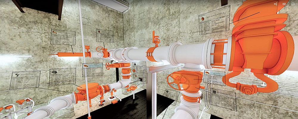
Reality Capture & CAD Services
Go to product
A selection of suitable use cases for products or services provided by verified companies according to your search.
Use case
Reality Capture + Asset Information Modeling
Manufacturing, Factory, Production Plant
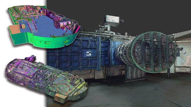
PMI was asked to participate in a pump station renovation in which asset and building life cycle management were high priority. Capturing post demolition conditions with terrestrial laser scanning assisted with the design process, and scanning final construction validated construction, graduating the design documents to as record drawing relevant for management of the building life cycle. The record drawings feature asset data such as model information and serial numbers for major equipment, key information for maintenance and repair.
Use case
Reality Capture + Asset Information Modeling
Manufacturing, Factory, Production Plant
PMI was asked to participate in a pump station renovation in which asset and building life cycle management were high priority. Capturing post demolition conditions with terrestrial laser scanning assisted with the design process, and scanning final construction validated construction, graduating the design documents to as record drawing relevant for management of the building life cycle. The record drawings feature asset data such as model information and serial numbers for major equipment, key information for maintenance and repair.
When exploring the LiDAR industry in Brazil, several key considerations emerge. The regulatory landscape is crucial, as Brazil has specific laws governing aerial surveys and environmental protection, particularly in sensitive areas like the Amazon rainforest. Familiarity with these regulations is essential for compliance and successful project execution. Additionally, the industry faces challenges such as limited infrastructure in remote regions and the need for skilled professionals capable of operating advanced LiDAR technology. However, opportunities abound in sectors like agriculture, forestry, and urban planning, as LiDAR's applications for mapping and analysis grow increasingly vital in these fields. The competitive landscape features a mix of local firms and international companies, which can influence pricing and technology access. Brazil's LiDAR market is also impacted by global trends, such as the increasing adoption of geospatial technologies and the growing emphasis on sustainability. Environmental concerns are significant, as LiDAR can aid in monitoring deforestation and land use changes, aligning with broader conservation efforts. Understanding these dynamics can help stakeholders navigate the complexities of the market and leverage LiDAR technology effectively to meet diverse needs and challenges within Brazil.
Some interesting numbers and facts about your company results for LiDAR
| Country with most fitting companies | Brazil |
| Amount of fitting manufacturers | 15 |
| Amount of suitable service providers | 4 |
| Average amount of employees | 1-10 |
| Oldest suiting company | 1998 |
| Youngest suiting company | 2017 |
Some interesting questions that has been asked about the results you have just received for LiDAR
What are related technologies to LiDAR?
Based on our calculations related technologies to LiDAR are Magnets, Printed Electronics, Industrial Amplifiers, Electronic Transducers, Electronic Oscillators
Which industries are mostly working on LiDAR?
The most represented industries which are working in LiDAR are IT, Software and Services, Construction, Other, Mining, Automation
How does ensun find these LiDAR Companies?
ensun uses an advanced search and ranking system capable of sifting through millions of companies and hundreds of millions of products and services to identify suitable matches. This is achieved by leveraging cutting-edge technologies, including Artificial Intelligence.