Locations
Company type
Result types
Industries
Employees
Founding year

The B2B platform for the best purchasing descision. Identify and compare relevant B2B manufacturers, suppliers and retailers
Close
Filter
Result configuration
Continents
Select continent
Locations
Result types
Company type
Select company type
Industries
Select industry
Company status
Select company status preset
Number of employees
Min.
Max.
Founding year
TAH-LI
Singapore
C
1-10 Employees
1995
Key takeaway
TAH-LI Engineering Private Limited specializes in 3D mapping and scanning solutions, making it well-equipped to cater to the needs of industries that require advanced surveying technologies like LiDAR. As an authorized dealer for Leica Geosystems, the company emphasizes delivering high-quality products and services to its esteemed clientele.
Reference
Product
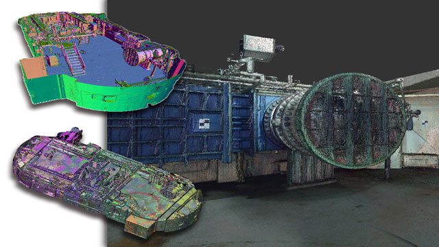
Tah-Li Engineering Pte Ltd - 3D Laser Scanners
Vilota Pte Ltd
Singapore
C
1-10 Employees
2021
Key takeaway
VILOTA addresses localization challenges in various industries by developing Visual Positioning Systems (VPS) that provide precise positioning without relying on GNSS. Their technology integrates stereo cameras and inertial sensors to enable real-time tracking and motion estimation, making it particularly effective for environments where GPS signals are weak or unavailable.
Reference
Product
Technology
VIlot
H3 Geospatial Technologies Pte Ltd
Singapore
C
11-50 Employees
2021
Key takeaway
The company specializes in providing advanced geospatial and 3D solutions, utilizing cutting-edge technologies like AI and 5G. Their expertise and diverse product offerings, including precision instruments, cater to various client needs and budgets.
Reference
Product
Precision Laser Plummet – H3 Geospatial Technologies Pte Ltd
Looking for more accurate results?
Find the right companies for free by entering your custom query!
25M+ companies
250M+ products
Free to use
OPERVA.AI
Singapore
C
1-10 Employees
2020
Key takeaway
Operva AI Facade Inspection utilizes advanced drones equipped with high-resolution cameras and sensors to enhance facade inspections, ensuring accuracy and efficiency. Their AIRPLAND suite also offers site mapping services that leverage drone technology for precise and up-to-date project visualization.
Reference
Core business
Home - OPERVA AI
Fly The Future Where Precision Takes Flight, Transforming Industries with Drone Innovation Unleash the Power of Aerial Innovation: Elevate Your Business with OPERVA.AI's Cutting-Edge Drone Solutions Explore Our Services Periodic Facade Inspection Our Periodic Facade Inspection service revolutionizes building maintenance with the power of aerial technology. By utilizing state-of-the-art drones equipped with high-resolution cameras and
SkyMap Global Pte Ltd
Singapore
C
51-100 Employees
2013
Key takeaway
The company specializes in building operational technology solutions and offers advanced data products and services, including satellite image processing for various applications like change detection and feature extraction. Their use of AI and machine learning to create and update digital maps suggests a focus on innovative mapping technologies that could relate to LiDAR applications.
Reference
Core business
Skymap Global Homepage – Earth Observation Analytics
FlyingBots
Singapore
C
1-10 Employees
2015
Key takeaway
Flying Bots Pte Ltd specializes in Unmanned Aerial Vehicle (UAV) technology and offers high-quality flight controllers and accessories that can enhance drone operations. Notably, they provide the DJI Zenmuse L1, which is likely relevant for LiDAR applications.
Reference
Product
DJI Enterprise Drones Singapore | Flying Bots » DJI Zenmuse L1

AeroLion Technologies
Singapore
C
11-50 Employees
-
Key takeaway
The company specializes in designing and optimizing autonomous drones for stock counting, which could be relevant for applications in LiDAR technology.
Reference
Core business
Aerolion Technologies | Drone Inspections & Surveys in Singapore
Aerolion Technologies is the leading drone inspection and survey provider in Singapore. Serving private and government agencies around Asia.
Lauretta.io
Singapore
C
1-10 Employees
2015
Key takeaway
Lauretta.io is dedicated to leveraging AI technology for predictive analytics and optimizing business operations, which could be relevant in the context of LiDAR applications. Their focus on AI-powered analytics solutions may also enhance understanding and insights in various fields.
Reference
Core business
Company | Lauretta.io | Autonomous Property Management with Video Analytics
DigitwinSG
Singapore
C
11-50 Employees
2020
Key takeaway
DigiTwinSG, a division of YJP Surveyors in Singapore, specializes in capturing and digitizing real-world spaces through advanced laser scanning services. Their partnership with Phoenix Lidar underscores their commitment to delivering exceptional 3D scanning solutions across various industries.
Reference
Core business
3d Scanning | DigitwinSG | Singapore
3d Scanning | DigitwinSG | Singapore We offer advanced laser scanning services for all industries.
EOfactory
Singapore
C
11-50 Employees
2020
Key takeaway
EOFactory provides highly accurate measurements from satellite imagery, which can be beneficial for LiDAR analysis. Their focus on accuracy and geospatial intelligence software may enhance the effectiveness of LiDAR data integration and interpretation.
Reference
Core business
Geospatial Intelligence Software, GIS Mapping Software - Eofactory.ai
Technologies which have been searched by others and may be interesting for you:
A selection of suitable products and services provided by verified companies according to your search.
Service
Reality Capture & CAD Services
Go to product
A selection of suitable use cases for products or services provided by verified companies according to your search.
Use case
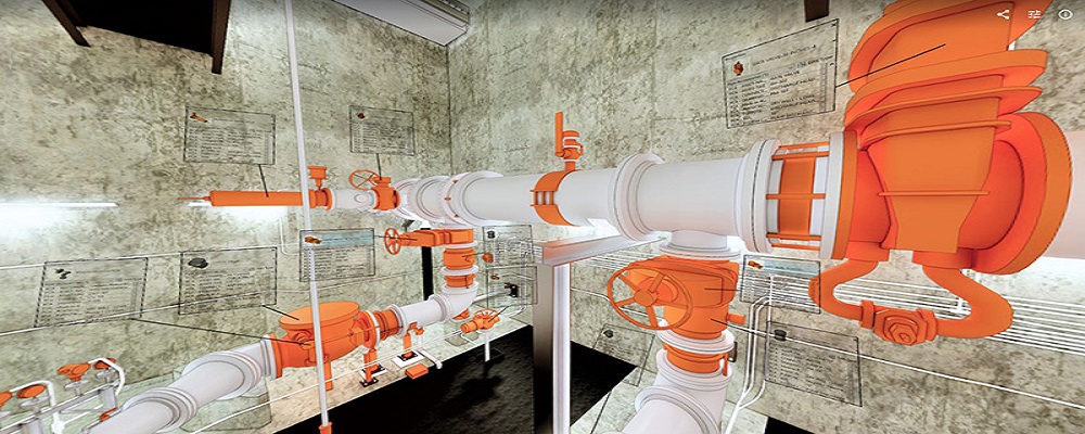
Reality Capture + Asset Information Modeling
Manufacturing, Factory, Production Plant
PMI was asked to participate in a pump station renovation in which asset and building life cycle management were high priority. Capturing post demolition conditions with terrestrial laser scanning assisted with the design process, and scanning final construction validated construction, graduating the design documents to as record drawing relevant for management of the building life cycle. The record drawings feature asset data such as model information and serial numbers for major equipment, key information for maintenance and repair.
Use case
Reality Capture + Asset Information Modeling
Manufacturing, Factory, Production Plant
PMI was asked to participate in a pump station renovation in which asset and building life cycle management were high priority. Capturing post demolition conditions with terrestrial laser scanning assisted with the design process, and scanning final construction validated construction, graduating the design documents to as record drawing relevant for management of the building life cycle. The record drawings feature asset data such as model information and serial numbers for major equipment, key information for maintenance and repair.
For those interested in the LiDAR industry in Singapore, several key considerations are essential. First, it's important to understand the regulatory landscape, as compliance with local laws and international standards is crucial for operations. The Land Surveyors Act and various environmental regulations influence how LiDAR technologies can be deployed. Another significant factor is the competitive landscape, which includes both established firms and emerging startups, each vying for a share of the growing market. Opportunities in Singapore are driven by urban development, infrastructure projects, and smart city initiatives that require precise mapping and data collection. The government’s support for technology adoption also enhances the potential for innovation in this sector. Environmental concerns are increasingly relevant, particularly in relation to land use and conservation efforts, making LiDAR’s ability to provide non-invasive data collection valuable. Moreover, understanding the global market relevance of LiDAR technology is vital, as Singapore serves as a regional hub for various industries. This positioning allows for collaboration and knowledge exchange, further driving growth. Overall, staying informed about technological advancements, market demands, and regulatory changes will be key for anyone looking to successfully navigate the LiDAR landscape in Singapore.
Some interesting numbers and facts about your company results for LiDAR
| Country with most fitting companies | Singapore |
| Amount of fitting manufacturers | 61 |
| Amount of suitable service providers | 47 |
| Average amount of employees | 11-50 |
| Oldest suiting company | 1995 |
| Youngest suiting company | 2021 |
Some interesting questions that has been asked about the results you have just received for LiDAR
What are related technologies to LiDAR?
Based on our calculations related technologies to LiDAR are Magnets, Printed Electronics, Industrial Amplifiers, Electronic Transducers, Electronic Oscillators
Who are Start-Ups in the field of LiDAR?
Start-Ups who are working in LiDAR are Vilota Pte Ltd, H3 Geospatial Technologies Pte Ltd
Which industries are mostly working on LiDAR?
The most represented industries which are working in LiDAR are IT, Software and Services, Automation, Construction, Other, Business Supplies and Equipment
How does ensun find these LiDAR Companies?
ensun uses an advanced search and ranking system capable of sifting through millions of companies and hundreds of millions of products and services to identify suitable matches. This is achieved by leveraging cutting-edge technologies, including Artificial Intelligence.