Locations
Company type
Result types
Industries
Employees
Founding year

The B2B platform for the best purchasing descision. Identify and compare relevant B2B manufacturers, suppliers and retailers
Close
Filter
Result configuration
Continents
Select continent
Locations
Result types
Company type
Select company type
Industries
Select industry
Company status
Select company status preset
Number of employees
Min.
Max.
Founding year
ABC Surveys
Dubai, United Arab Emirates
C
11-50 Employees
2007
Key takeaway
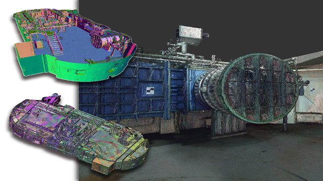
ABC Surveys is a leading organization in the field of 3D laser scanning and has established a partnership with FARO®, a trusted source for high-precision 3D measurement and imaging technology. This expertise in 3D laser scanning is closely related to the use of LiDAR technology for accurate data capture and analysis.
Reference
Service
3D Laser scanning | ABC Surveys
Airscope - Professional Drone Services and Solutions- Leading Middle East Drone Operator
Dubai, United Arab Emirates
C
11-50 Employees
2016
Key takeaway
Airscope is a leading drone operator in the Middle East, offering a range of aerial services including autonomous drone surveys and visual inspection services. With a focus on quality and cutting-edge technology, they provide tailored drone solutions that could be relevant for applications involving LiDAR.
Reference
Product
Technology – Airscope Technologies
GECO Engineering Equipments LLC
Dubai, United Arab Emirates
C
11-50 Employees
1970
Key takeaway
The company offers advanced surveying products, including the Leica Aibot CX UAV solution, which enhances construction progress monitoring and topographic surveys. Their commitment to innovation and quality positions them as a key player in geosystems solutions that capture and virtualize data effectively.
Reference
Product
Leica Aibot CX for Construction – Home
Requirements and expectations from engineers, site manager, construction companies, regulators and public administrations keep increasing. When more material needs to be moved quicker and operating margins get tighter, the bar for new technologies is raised. To get a clear and up-to-date view over construction progress and earthmovings, the Leica Aibot CX solution
Looking for more accurate results?
Find the right companies for free by entering your custom query!
25M+ companies
250M+ products
Free to use
DroneLeaf LLC
Abu Dhabi, United Arab Emirates
C
1-10 Employees
2020
Key takeaway
DroneLeaf specializes in developing innovative AI solutions for unmanned systems, enhancing their autonomy and operational capabilities. Their advanced flight controller optimizes drone performance, which could be relevant for applications utilizing LiDAR technology.
Reference
Core business
Home - DroneLeaf
Providing AI solutions for unmanned systems
Rise Geo Control Systems Trading L.L.C
Dubai, United Arab Emirates
C
11-50 Employees
2010
Key takeaway
RISE GEO offers advanced airborne LiDAR payloads as part of its comprehensive range of surveying equipment and solutions. This positions the company as a key supplier for those seeking innovative technologies in land surveying and industrial applications.
Reference
Product
Buy ars-series-airborne-lidar-payloads from Rise Geo Control Systems.
GIS Drones™
Dubai, United Arab Emirates
C
11-50 Employees
2020
Key takeaway
The company, GIS Drones, specializes in providing advanced drone solutions for various industries, including surveying and mapping, which are essential applications of LiDAR technology. Their services aim to enhance operational efficiency and support digital transformation initiatives, making them a key player in the drone inspection and surveying sector.
Reference
Core business
Best Drones Inspection And Surveying Company In Dubai, UAE
We are a full-service drone-powered solutions company based in Dubai. We supply quality Drones Inspection to Businesses and Media.
Space Imaging Middle East
Dubai, United Arab Emirates
C
11-50 Employees
1997
Key takeaway
The company offers high-resolution aerial imagery and satellite imagery, which can be utilized for building LiDAR point clouds and advanced GIS solutions, making it a valuable resource for organizations in need of detailed geospatial data.
Reference
Core business
Space Imaging Middle East – Your Total Geospatial Solutions Provider
The Power of Satellites in the Palm of Your Hand We provide organizations with satellite imagery with up to 15cm resolution, aerial imagery for a variety of use cases such as building LiDAR point clouds, imagery processing and sophisticated GIS solutions to solve those tough problems.
Ultimate Accuracy Surveying Engineering Services
Dubai, United Arab Emirates
C
1-10 Employees
2021
Key takeaway
The company emphasizes its expertise in high-precision devices and software, which likely includes advanced technologies like LiDAR for ultimate accuracy in 3D scanning and surveying. Their commitment to high accuracy and cost-effective solutions aligns with the needs of projects that require detailed spatial data.
Reference
Core business
3D Scanning - Ultimate Accuracy Surveying Engineering Solutions
From start to finish, we help get the job done! we are expert in engineering consultant
SkyStance
Dubai, United Arab Emirates
C
1-10 Employees
2017
Key takeaway
Skystance specializes in advanced drone technology and offers a range of aerial services, including aerial surveying and mapping, which are directly relevant to LiDAR applications. Their commitment to providing innovative and cost-effective solutions ensures they meet diverse industry needs effectively.
Reference
Service
Our Services – skystance
PerigonAI
Dubai, United Arab Emirates
C
11-50 Employees
-
Key takeaway
PerigonAI is a leading geospatial artificial intelligence platform that utilizes cutting-edge machine learning and AI technology. Their innovative solutions have enabled clients to develop long-term growth strategies through advanced predictions.
Reference
Core business
Home - PerigonAI
Technologies which have been searched by others and may be interesting for you:
A selection of suitable products and services provided by verified companies according to your search.
Service
Reality Capture & CAD Services
Go to product
A selection of suitable use cases for products or services provided by verified companies according to your search.
Use case
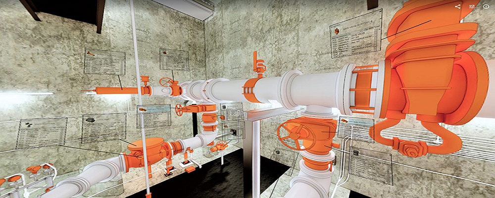
Reality Capture + Asset Information Modeling
Manufacturing, Factory, Production Plant
PMI was asked to participate in a pump station renovation in which asset and building life cycle management were high priority. Capturing post demolition conditions with terrestrial laser scanning assisted with the design process, and scanning final construction validated construction, graduating the design documents to as record drawing relevant for management of the building life cycle. The record drawings feature asset data such as model information and serial numbers for major equipment, key information for maintenance and repair.
Use case
Reality Capture + Asset Information Modeling
Manufacturing, Factory, Production Plant
PMI was asked to participate in a pump station renovation in which asset and building life cycle management were high priority. Capturing post demolition conditions with terrestrial laser scanning assisted with the design process, and scanning final construction validated construction, graduating the design documents to as record drawing relevant for management of the building life cycle. The record drawings feature asset data such as model information and serial numbers for major equipment, key information for maintenance and repair.
In the United Arab Emirates, the LiDAR industry presents unique opportunities and challenges that potential entrants should consider. Regulatory frameworks are evolving, with a focus on compliance with local laws regarding data privacy and environmental protection. Companies must navigate the requirements set forth by the UAE government, especially in sectors like construction and urban planning, where accurate topographical data is essential. Additionally, the competitive landscape is becoming more dynamic, with both local and international players vying for market share. It's crucial to assess the technology's applicability across various sectors, including infrastructure development, environmental monitoring, and agriculture, as these areas are experiencing significant investment. Environmental concerns are also prominent, as LiDAR technology can aid in habitat preservation and urban planning by providing precise data to inform sustainable practices. Furthermore, global market relevance cannot be overlooked, as the UAE aims to position itself as a hub for technological innovation in the Middle East. Understanding the interplay between local market demands and global trends is essential for success in this sector. By focusing on these factors, stakeholders can effectively navigate the complexities of the LiDAR industry in the UAE.
Some interesting numbers and facts about your company results for LiDAR
| Country with most fitting companies | United Arab Emirates |
| Amount of fitting manufacturers | 52 |
| Amount of suitable service providers | 49 |
| Average amount of employees | 11-50 |
| Oldest suiting company | 1970 |
| Youngest suiting company | 2021 |
Some interesting questions that has been asked about the results you have just received for LiDAR
What are related technologies to LiDAR?
Based on our calculations related technologies to LiDAR are Magnets, Printed Electronics, Industrial Amplifiers, Electronic Transducers, Electronic Oscillators
Who are Start-Ups in the field of LiDAR?
Start-Ups who are working in LiDAR are Ultimate Accuracy Surveying Engineering Services
Which industries are mostly working on LiDAR?
The most represented industries which are working in LiDAR are IT, Software and Services, Other, Construction, Electronics and Electrical engineering, Defense
How does ensun find these LiDAR Companies?
ensun uses an advanced search and ranking system capable of sifting through millions of companies and hundreds of millions of products and services to identify suitable matches. This is achieved by leveraging cutting-edge technologies, including Artificial Intelligence.