Locations
Company type
Result types
Industries
Employees
Founding year

The B2B platform for the best purchasing descision. Identify and compare relevant B2B manufacturers, suppliers and retailers
Close
Filter
Result configuration
Continents
Select continent
Locations
Result types
Company type
Select company type
Industries
Select industry
Company status
Select company status preset
Number of employees
Min.
Max.
Founding year
ITS Perception AS
Norway
A
1-10 Employees
2017
Key takeaway
Raywiz specializes in LiDAR technology and offers a range of products and solutions in this field, leveraging their expertise to assist customers throughout the entire product life cycle.
Reference
Product
Products | Raywiz
- Real Time Insights -
KVS Technologies
Stavanger, Norway
A
11-50 Employees
2015
Key takeaway
Field is a geospatial technology company that specializes in topographical LiDAR, having pioneered airborne and car-borne laser scanning in the Nordics. Their expertise in capturing and processing accurate geospatial information positions them as leaders in this innovative field.
Reference
Service
Topographical lidar - Field
Laser scanning has gradually become a standard method for digitizing 3D terrain. Field has been leading the way as the first company in Nordics to start with airborne and later car-borne laser scanning.
Geograf Digital AS
Stavanger, Norway
A
11-50 Employees
1996
Key takeaway
Geograf Digital AS is focused on setting the standard for digitalization in the construction industry through various technologies, including laser scanning, which is closely related to LiDAR. Their expertise in 3D scanning and digital twin production positions them as a key player in innovative construction solutions.
Reference
Core business
Geograf Digital - Vi digitaliserer byggebransjen
Geograf Digital setter standarder for digitalisering i byggebransjen ved hjelp av ulike teknologier som drone, NavVis, laser, GPR og landseismikk.
Looking for more accurate results?
Find the right companies for free by entering your custom query!
25M+ companies
250M+ products
Free to use
Hawkeye
Bjørnafjorden, Norway
A
1-10 Employees
2014
Key takeaway
Hawkeye AS specializes in aerial mapping, 3D laser scanning, and drone inspections, leveraging over 1500 drone operations to ensure high-quality deliverables. Their expertise in creating complex 3D models from captured data makes them well-suited for "AS BUILT" documentation and project planning.
Reference
Core business
Hawkeye AS - drone, 3d laser skann, mobile mapping, rådgiving, geomatikk
Scan Survey AS
Oslo, Norway
A
11-50 Employees
1989
Key takeaway
Scan Survey offers a range of surveying services, including laserskanning, which is closely related to LiDAR technology, providing detailed point clouds and 3D models essential for various projects. Their expertise in mobile mapping and terrain modeling supports effective planning and execution of construction and infrastructure projects.
Reference
Service
Mobile Mapping - Scan Survey
Scan Survey operates the mobile mapping system Leica Pegasus:Backpack. We cater for all your needs providing detailed pointclouds, 3D models and terrain models.
North GeoServices AS
Oslo, Norway
A
1-10 Employees
2020
Key takeaway
North GeoServices employs unique acquisition methods and technology to deliver high and ultra-high resolution data, which is crucial for applications like renewable site development and carbon capture storage identification.
Reference
Core business
North GeoServices | All-In-One Survey Solutions
North GeoServices provider of All-In-One survey solutions for emerging green markets.
BuildingPoint Scandinavia
Bærum, Norway
A
51-100 Employees
2019
Key takeaway
BuildingPoint Scandinavia offers advanced technology solutions for the construction industry, including Trimble's 3D Laser Scanning and Trimble RealWorks, which are essential for effective LiDAR applications. Their expertise in software and hardware, combined with a focus on innovation, positions them as a key player in the Nordic market for cutting-edge construction methods.
Reference
Product
3D Laser Scanning — Product Catalogue — BuildingPoint Scandinavia
Geoprovider
Stavanger, Norway
A
11-50 Employees
2013
Key takeaway
GeoProvider is a leading Norwegian service company that specializes in Marine Geoscience and Site Survey Services, utilizing advanced technology for high-quality data collection and integration. Their expertise in data mining and processing may be relevant for applications involving LiDAR technology.
Reference
Core business
Home - Geoprovider
GeoProvider is a recognised Norwegian consultancy firm specialising in Marine Geoscience, Geotechnics, High Resolution Seismic Processing, and Site Survey Services. Offshore Wind, E&P, seabed minerals.
SCANDINAVIAN DRONE
Bergen, Norway
A
1-10 Employees
2016
Key takeaway
YellowScan is showcasing its new bathymetric LiDAR system, which is designed for capturing precise imagery to create photogrammetric models. Their compact drone, Mavic 3T, is ready for missions when needed and easy to store when not in use, enhancing operational efficiency.
Reference
Product
Pix4D Cloud - Bestill Online på ScandinavianDrone.no
Pix4D Cloud er en skyløsning for fotogrammetri som gjør det super enkelt å lage 3D modeller og kart som du kan dele med andre.
EMerald Geomodelling
Oslo, Norway
A
1-10 Employees
2018
Key takeaway
The company, EMerald Geomodelling, specializes in delivering integrated 3D models that leverage AI and machine learning to provide accurate subsurface imagery, which is essential for understanding ground conditions in infrastructure projects. With over 12 years of experience, they aim to reduce risks and costs, ensuring faster and more reliable project outcomes.
Reference
Core business
EMerald Geomodelling - Reduce Risk in Infrastructure Projects
Profit from a time-efficient and more affordable way to uncover ground conditions in the project area.
Technologies which have been searched by others and may be interesting for you:
A selection of suitable products and services provided by verified companies according to your search.
Service
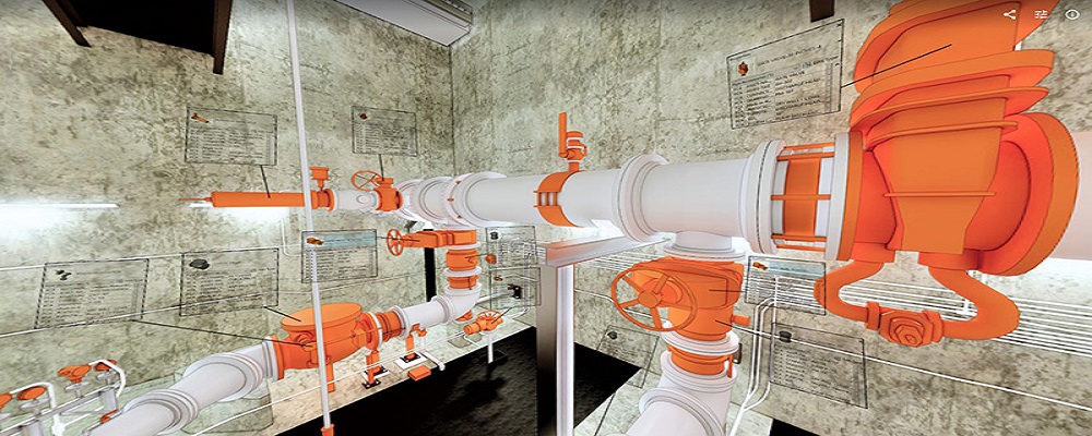
Reality Capture & CAD Services
Go to product
A selection of suitable use cases for products or services provided by verified companies according to your search.
Use case
Reality Capture + Asset Information Modeling
Manufacturing, Factory, Production Plant
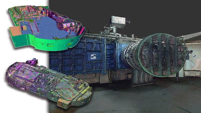
PMI was asked to participate in a pump station renovation in which asset and building life cycle management were high priority. Capturing post demolition conditions with terrestrial laser scanning assisted with the design process, and scanning final construction validated construction, graduating the design documents to as record drawing relevant for management of the building life cycle. The record drawings feature asset data such as model information and serial numbers for major equipment, key information for maintenance and repair.
Use case
Reality Capture + Asset Information Modeling
Manufacturing, Factory, Production Plant
PMI was asked to participate in a pump station renovation in which asset and building life cycle management were high priority. Capturing post demolition conditions with terrestrial laser scanning assisted with the design process, and scanning final construction validated construction, graduating the design documents to as record drawing relevant for management of the building life cycle. The record drawings feature asset data such as model information and serial numbers for major equipment, key information for maintenance and repair.
When exploring the LiDAR industry in Norway, several key considerations come into play. First, the regulatory environment is crucial; Norway has strict environmental regulations that impact how LiDAR data is collected and used, particularly in sensitive areas like forests and wetlands. Companies must navigate these regulations carefully to ensure compliance. The competitive landscape is characterized by a mix of established firms and innovative startups, making it essential to assess the capabilities and technologies offered by various players in the market. Additionally, opportunities abound in fields such as forestry, agriculture, and urban planning, where LiDAR technology is increasingly adopted for mapping and analysis. Environmental concerns also drive the demand for LiDAR, as it provides precise data for monitoring changes in ecosystems. Furthermore, the global market relevance of LiDAR technology continues to grow, with applications extending beyond Norway to international markets, particularly in sectors like autonomous vehicles and infrastructure development. Understanding these aspects can help potential stakeholders make informed decisions and foster successful engagements in the LiDAR industry within Norway.
Some interesting numbers and facts about your company results for LiDAR
| Country with most fitting companies | Norway |
| Amount of fitting manufacturers | 90 |
| Amount of suitable service providers | 48 |
| Average amount of employees | 11-50 |
| Oldest suiting company | 1989 |
| Youngest suiting company | 2020 |
Some interesting questions that has been asked about the results you have just received for LiDAR
What are related technologies to LiDAR?
Based on our calculations related technologies to LiDAR are Magnets, Printed Electronics, Industrial Amplifiers, Electronic Transducers, Electronic Oscillators
Which industries are mostly working on LiDAR?
The most represented industries which are working in LiDAR are IT, Software and Services, Other, Oil, Energy and Gas, Automation, Electronics and Electrical engineering
How does ensun find these LiDAR Companies?
ensun uses an advanced search and ranking system capable of sifting through millions of companies and hundreds of millions of products and services to identify suitable matches. This is achieved by leveraging cutting-edge technologies, including Artificial Intelligence.