Locations
Company type
Result types
Industries
Employees
Founding year

The B2B platform for the best purchasing descision. Identify and compare relevant B2B manufacturers, suppliers and retailers
Close
Filter
Result configuration
Continents
Select continent
Locations
Result types
Company type
Select company type
Industries
Select industry
Company status
Select company status preset
Number of employees
Min.
Max.
Founding year
AMI Systems
Gdynia, Poland
B
1-10 Employees
2020
Key takeaway
The company offers high-quality UAV LiDAR services that provide accurate ground measurements in densely vegetated areas and forests, utilizing advanced SLAM algorithms for indoor scanning. They emphasize the importance of comprehensive pre-construction surveys and the capability to deliver detailed digital terrain models.
Reference
Service
Services – AMI Systems
LiDAR scanning service Hire AMI Systems to collect LiDAR data utilizing the best combination of multi-vehicle LiDAR & SLAM scanning techniques. We will process the acquired data in desktop or online workflow and present you the georeferenced, colorized and classified point cloud and other deliverables of your choice. read more Rent a LiDAR System Choose…
KPGeo
Krakow, Poland
B
11-50 Employees
2012
Key takeaway
KPGeo specializes in providing professional data services, including a wide range of geospatial services such as aerial, terrestrial, and mobile LiDAR products. Their offerings include LiDAR-based vector and raster products, point cloud classification, and DTM development, highlighting their expertise in high-accuracy LiDAR solutions for complex projects.
Reference
Product
LIDAR - KPGeo
Robotec.AI
Warsaw, Poland
B
11-50 Employees
2019
Key takeaway
Robotec.ai specializes in developing advanced solutions for autonomous vehicles, with a focus on LIDAR-based components of the autonomous vehicle stack, highlighting their expertise in testing and validation services for these technologies.
Reference
Service
LIDAR-based parts of AV stack - Robotec.ai
Looking for more accurate results?
Find the right companies for free by entering your custom query!
25M+ companies
250M+ products
Free to use
Orbify
Krakow, Poland
B
1-10 Employees
2021
Key takeaway
Orbify highlights the potential of space-derived data, offering a user-friendly platform that enables quick access to high-resolution land cover and remote sensing data analysis. Their focus on streamlining the technology stack allows users, including city planners, to efficiently leverage insights for environmental assessment and decision-making.
Reference
Core business
Geospatial Data Platform for Natural Assets Monitoring | Orbify
Easily access ready-to-use remote sensing data analysis using cutting-edge ML models. Designed for Nature-based Solutions (NbS), ESG & Sustainable Development Goals.
FLOTA 3D
Poland
B
11-50 Employees
-
Key takeaway
The company provides high-quality LiDAR data acquisition using UAVs and aircraft, delivering point clouds in grayscale with registered intensity or in natural RGB colors. They also offer advanced data processing and create various photogrammetric products, including orthophotos and Digital Terrain Models.
Reference
Core business
Flota 3D – Skanowanie laserowe 3D – Fotogrametria UAV – Lidar
Zajmujemy się tworzeniem profesjonalnych zobrazowań przestrzennych przy wykorzystaniu technik fotogrametrii naziemnej i lotniczej.
Lasertex sp. z o.o.
Wrocław, Poland
B
11-50 Employees
1989
Key takeaway
Lasertex Ltd specializes in high-precision measuring equipment, including their Lasertex HPI-3D linear laser interferometer, which is designed for geometry testing of CNC machines and more. With over 30 years of scientific research, Lasertex combines advanced laser optics and unique software for precise measurements, making it a valuable resource for students and researchers.
Reference
Product
Lasertex HPI-3D Linear laser interferometer
High precision and high resolution laser encoder with unique electronic fast adjustment software and 3D analysis 3 axles at once.
Valo Industries
Wrocław, Poland
B
1-10 Employees
2018
Key takeaway
Valo Industries is focused on scaling drone services through remote operations, allowing for global service provision. This capability could enhance applications like LiDAR, where efficient and widespread data collection is essential.
Reference
Core business
About |VALO INDUSTRIES |Drone charging platform|Drone docking station
VALO INDUSTRIES | ABOUT US | BOARD | Drone charging platform | Drone docking station | Drone charging station | Drone docking platform |
Digital Scan Solutions
Poland
B
1-10 Employees
2020
Key takeaway
Digital Scan Solutions specializes in 3D and 2D projects using data from laser scanning and photogrammetric surveys. They provide services that include creating point clouds and final products like 3D models and CAD drawings, highlighting their expertise in laser scanning technology.
Reference
Core business
Digital Scan Solutions – Skanowanie 3D
BIMfaktoria
Warsaw, Poland
B
1-10 Employees
2019
Key takeaway
BIMfaktoria specializes in 3D laser scanning and offers PointCab software for processing high-resolution point clouds, which is essential for effective project management and execution, particularly for projects based on LiDAR technology.
Reference
Core business
About us - Laser scanning services - BIMfaktoria
We provide services in digitizing objects using 3D laser scanning and photogrammetry, as well as BIM digital technologies.
Lenslist
Warsaw, Poland
B
1-10 Employees
2017
Key takeaway
Lenslist is dedicated to developing and promoting AR, VR, and MR solutions, highlighting their role as curators and experts in the XR community. Their focus on collaboration with creators and sharing expertise positions them as key players in the evolving landscape of immersive technologies.
Reference
Core business
About | Lenslist
Join our Community of 10,000+ XR Creators
Technologies which have been searched by others and may be interesting for you:
A selection of suitable products and services provided by verified companies according to your search.
Service
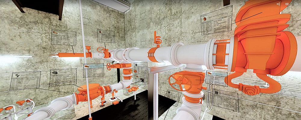
Reality Capture & CAD Services
Go to product
A selection of suitable use cases for products or services provided by verified companies according to your search.
Use case
Reality Capture + Asset Information Modeling
Manufacturing, Factory, Production Plant
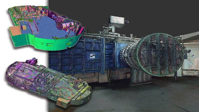
PMI was asked to participate in a pump station renovation in which asset and building life cycle management were high priority. Capturing post demolition conditions with terrestrial laser scanning assisted with the design process, and scanning final construction validated construction, graduating the design documents to as record drawing relevant for management of the building life cycle. The record drawings feature asset data such as model information and serial numbers for major equipment, key information for maintenance and repair.
Use case
Reality Capture + Asset Information Modeling
Manufacturing, Factory, Production Plant
PMI was asked to participate in a pump station renovation in which asset and building life cycle management were high priority. Capturing post demolition conditions with terrestrial laser scanning assisted with the design process, and scanning final construction validated construction, graduating the design documents to as record drawing relevant for management of the building life cycle. The record drawings feature asset data such as model information and serial numbers for major equipment, key information for maintenance and repair.
When exploring the LiDAR industry in Poland, several key considerations emerge. The regulatory framework is crucial, as Poland adheres to EU regulations regarding data privacy and aerial surveying, which can impact LiDAR operations. Understanding these regulations will help ensure compliance and smooth project execution. Additionally, the competitive landscape is evolving, with both established players and startups entering the market, driving innovation and collaboration opportunities. Challenges such as the need for skilled personnel and the high cost of cutting-edge technology can pose barriers to entry. However, the demand for LiDAR services in sectors like forestry, agriculture, and urban planning presents significant growth opportunities. Environmental concerns are also relevant; LiDAR's non-invasive nature makes it an attractive option for data collection in sensitive areas, aligning with sustainability goals. Moreover, Poland's strategic location in Europe provides access to international markets, enhancing its global relevance in the LiDAR sector. Companies must stay informed about technological advancements and market trends to remain competitive and leverage the potential of this rapidly growing industry.
Some interesting numbers and facts about your company results for LiDAR
| Country with most fitting companies | Poland |
| Amount of fitting manufacturers | 65 |
| Amount of suitable service providers | 50 |
| Average amount of employees | 1-10 |
| Oldest suiting company | 1989 |
| Youngest suiting company | 2021 |
Some interesting questions that has been asked about the results you have just received for LiDAR
What are related technologies to LiDAR?
Based on our calculations related technologies to LiDAR are Magnets, Printed Electronics, Industrial Amplifiers, Electronic Transducers, Electronic Oscillators
Who are Start-Ups in the field of LiDAR?
Start-Ups who are working in LiDAR are Orbify
Which industries are mostly working on LiDAR?
The most represented industries which are working in LiDAR are IT, Software and Services, Other, Electronics and Electrical engineering, Manufacturing, Architecture and Planning
How does ensun find these LiDAR Companies?
ensun uses an advanced search and ranking system capable of sifting through millions of companies and hundreds of millions of products and services to identify suitable matches. This is achieved by leveraging cutting-edge technologies, including Artificial Intelligence.