The B2B platform for the best purchasing descision. Identify and compare relevant B2B manufacturers, suppliers and retailers
Close
Filter
Result configuration
Continents
Select continent
Locations
Result types
Company type
Select company type
Industries
Select industry
Company status
Select company status preset
Number of employees
Min.
Max.
Founding year
Phoenix Lidar Systems
Los Angeles, United States
B
11-50 Employees
2013
Key takeaway
Phoenix LiDAR Systems specializes in creating comprehensive 3D digital mapping solutions, emphasizing their expertise in UAV LiDAR mapping. Their innovative approach and quality hardware aim to provide efficient and effective surveying solutions for modern challenges.
Reference
Core business
Phoenix LiDAR Systems - Custom 3D Mapping Solutions
We build complete 3D digital mapping solutions crafted with quality hardware, intuitive software, and vehicle flexibility in mind – to deliver surveyor-friendly innovations, enabling faster, safer and more economical solutions without compromise.
Lumina Lidar
Greenwich, United States
B
11-50 Employees
2017
Key takeaway
Lumina Lidar specializes in high-quality 3D mapping and modeling, offering comprehensive LiDAR scanning services that include processing point clouds and creating 3D models and 2D floor plans. Their expertise in aerial LiDAR scanning ensures the collection of survey-grade accurate information, making them a valuable resource for projects requiring detailed topographical data.
Reference
Core business
Lumina Lidar | Creating Digital Twin | United States
Lumina Lidar offers top-quality 3D Mapping & Modeling. We use the finest remote sensing equipment "Digital Twin" to collect data that’s important to you, whether it’s Terrestrial, Aerial, or Mobile scanning, we got it.
Aerial Analytics LLC
Cary, United States
B
1-10 Employees
2019
Key takeaway
Aerial Analytics specializes in remote sensing data collection, employing advanced LiDAR technology to inspect and model the physical environment of asset-based resources for commercial and governmental use.
Reference
Core business
Lidar Mapping | Aerial Analytics | United States
Aerial Analytics LLC - UAS Data Collection for Asset Management & Evaluation
Looking for more accurate results?
Find the right companies for free by entering your custom query!
25M+ companies
250M+ products
Free to use
3DVES
Murrieta, United States
B
11-50 Employees
2015
Key takeaway
The company highlights that LiDAR, which stands for Light Detection and Ranging, uses laser pulses to create a visual representation of construction processes through point clouds, supported by photography and 360 videos. This technology can enhance the efficiency of complex MEP system designs in Autodesk Revit, saving time and money.
Reference
Product
LIDAR
VeriDaaS
Denver, United States
B
- Employees
-
Key takeaway
VeriDaaS specializes in high-resolution 3D data collection using Geiger-mode LiDAR, offering data processing and analysis services that enhance remote sensing and geospatial projects. Their high-density and highly accurate LiDAR data provide detailed insights that improve decision-making across various industries.
Reference
Core business
Lidar solutions - Lidar acquisition - VeriDaas Corporation
High density Lidar , highly accurate Lidar acquisition and LiDAR solutions using Remote sensing surveying, delivers more detailed information to enhance analysis and gain insight, resulting in improved decision-making capabilities.
LiDAR News
United States
B
1-10 Employees
1983
Key takeaway
Lidar News, a publication of MPN Components, Inc., is dedicated to promoting the growth of the LiDAR industry and providing current information on its applications and standards. As the demand for LiDAR and laser scanning technology continues to rise, particularly in the transition from 2D to 3D modeling, the publication highlights innovative uses of these technologies in enhancing visualization and modeling outcomes.
Reference
Core business
LiDAR News - Home of the LiDAR Industry
The Lidar News website was the first digital media platform dedicated solely to 3D technologies involving lidar, laser scanning and measurement.
BestLidar
Melbourne, United States
B
11-50 Employees
2021
Key takeaway
BestLIDAR specializes in advanced LiDAR technology, utilizing sophisticated image processing algorithms and machine learning to produce high-accuracy point clouds. Their solid-state LiDAR sensors are designed for various applications, particularly in the self-driving automotive industry, but also extend to robotics, maritime, aerial industries, smart cities, and digital twins.
Reference
Product
Technology | Solid State Lidar | BestLidar
Robota LLC
Dallas, United States
B
1-10 Employees
2011
Key takeaway
Robota Lidar offers a high-accuracy laser measurement system specifically designed for airborne scanning, making it ideal for applications such as land surveying. Their solutions integrate LIDAR technology with photogrammetry, enhancing the capabilities for generating precise 3D spatial data and models.
Reference
Product
Lidar | PPK GNSS Drone LIDAR
Robota Lidar is a laser measurement system for airborne scanning that offers high accuracy and streamlined workflows.
GreenValley International Inc
Berkeley, United States
B
51-100 Employees
2012
Key takeaway
GVI offers a comprehensive range of LiDAR technologies, including various high-precision 3D mapping hardware solutions such as unmanned aerial vehicle LiDAR and handheld LiDAR. Their product line is complemented by advanced software solutions for data acquisition, processing, and cloud-based management, making it a valuable resource for industries utilizing LiDAR.
Reference
Service
SERVICES-GreenValley International
LightWare LiDAR
Austin, United States
B
11-50 Employees
2012
Key takeaway
LightWare is a leading global manufacturer of microLiDAR® sensors, producing thousands each year to enhance machine perception and enable more effective operations. Their commitment to quality and innovation in LiDAR technology supports widespread industry adoption, making them a key player in advancing sensing solutions for various applications.
Reference
Core business
LightWare - the worlds smallest and lightest microLiDAR®
LightWare, leader in laser range-finder technology. We develop and distribute innovative laser rangefinder products for application across multiple industries. Responsiveness to our customers, product innovation, product & service quality, and business integrity are the core pillars of our success.
Technologies which have been searched by others and may be interesting for you:
A selection of suitable products and services provided by verified companies according to your search.

Service
Reality Capture & CAD Services
Go to product
A selection of suitable use cases for products or services provided by verified companies according to your search.

Use case
Reality Capture + Asset Information Modeling
Manufacturing, Factory, Production Plant
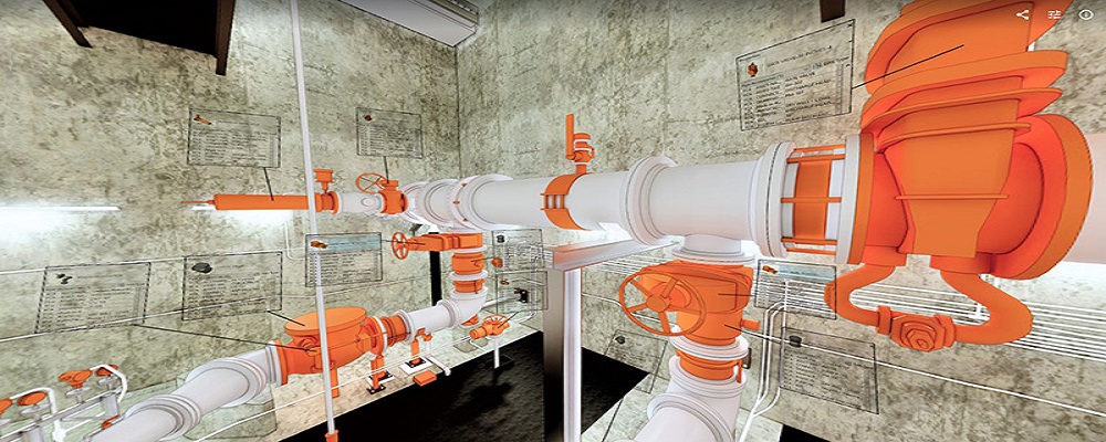
PMI was asked to participate in a pump station renovation in which asset and building life cycle management were high priority. Capturing post demolition conditions with terrestrial laser scanning assisted with the design process, and scanning final construction validated construction, graduating the design documents to as record drawing relevant for management of the building life cycle. The record drawings feature asset data such as model information and serial numbers for major equipment, key information for maintenance and repair.
When exploring the LiDAR industry in the United States, several key considerations are crucial. First, understanding the regulatory landscape is important, as federal and state regulations govern data collection methods and privacy concerns. Companies must comply with the Federal Aviation Administration (FAA) rules if using drones for aerial LiDAR. Challenges include high initial investment costs and the need for specialized training in data interpretation and software management. However, opportunities abound, particularly in sectors such as construction, forestry, and environmental monitoring, where LiDAR technology enhances accuracy and efficiency in mapping and surveying. The competitive landscape is evolving, with established firms and startups alike striving to innovate and improve technologies. Additionally, environmental concerns are gaining traction, prompting companies to adopt sustainable practices in data collection and processing. Global market relevance is significant, as advances in LiDAR technology are influencing applications worldwide, including urban planning and disaster management. Staying informed about technological advancements and market trends can provide a competitive edge in this rapidly growing field.
Some interesting numbers and facts about your company results for LiDAR
| Country with most fitting companies | United States |
| Amount of fitting manufacturers | 3101 |
| Amount of suitable service providers | 2516 |
| Average amount of employees | 11-50 |
| Oldest suiting company | 1983 |
| Youngest suiting company | 2021 |
Some interesting questions that has been asked about the results you have just received for LiDAR
What are related technologies to LiDAR?
Based on our calculations related technologies to LiDAR are Magnets, Printed Electronics, Industrial Amplifiers, Electronic Transducers, Electronic Oscillators
Who are Start-Ups in the field of LiDAR?
Start-Ups who are working in LiDAR are BestLidar
Which industries are mostly working on LiDAR?
The most represented industries which are working in LiDAR are IT, Software and Services, Other, Electronics and Electrical engineering, Construction, Aviation and Aerospace
How does ensun find these LiDAR Companies?
ensun uses an advanced search and ranking system capable of sifting through millions of companies and hundreds of millions of products and services to identify suitable matches. This is achieved by leveraging cutting-edge technologies, including Artificial Intelligence.