Locations
Company type
Result types
Industries
Employees
Founding year

The B2B platform for the best purchasing descision. Identify and compare relevant B2B manufacturers, suppliers and retailers
Close
Filter
Result configuration
Continents
Select continent
Locations
Result types
Company type
Select company type
Industries
Select industry
Company status
Select company status preset
Number of employees
Min.
Max.
Founding year
LiDAR PERU
Lima Metropolitan Area, Peru
C
11-50 Employees
2021
Key takeaway
Our LiDARit Explorer R sensor is a versatile tool that simplifies your project. With our intuitive LiDAR systems, you can access your LiDAR data, CAD drawings, digital models, measurements, and counts anytime, anywhere, with the option of expert assistance.
Reference
Product
Software - Lidar
Lidar Côte-d'Ivoire
Côte d'Ivoire
D
11-50 Employees
2019
Key takeaway
Lidar is a pioneering platform for agricultural and rural intelligence, offering tailored products and services primarily for crops like cocoa, coffee, cashew, and palm oil. The company specializes in developing effective and sustainable digital solutions for the agricultural sector.
Reference
Core business
Header – Lidar

LiDAR Solutions Australia
Melbourne, Australia
A
1-10 Employees
2019
Key takeaway
LiDAR Solutions, established in 2019 in Melbourne, specializes in providing high-quality LiDAR sensors and solutions that enhance measurement speed and accuracy for various applications, including wind measurement and robotics perception. Their expertise extends to a range of LiDAR products and point cloud processing software, making them a valuable resource for clients in the ANZ region.
Reference
Product
Lidar Surveying Instruments & Products | LiDAR Solutions Australia
Looking for reliable and high-quality Lidar surveying instruments and products? Enquire today and see our range of LiDAR equipment.
Looking for more accurate results?
Find the right companies for free by entering your custom query!
25M+ companies
250M+ products
Free to use
LidarSwiss Solutions GmbH
Buchs (SG), Switzerland
A
1-10 Employees
-
Key takeaway
LidarSwiss specializes in advanced LiDAR systems and software, partnering with top industry players to ensure high-quality calibration for optimal project outcomes. With a strong background in LiDAR technology, they offer innovative solutions like their 3D-Live system, which is particularly valued by first responders for rapid data acquisition and decision-making.
Reference
Product
3D Live - LidarSwiss Solutions GmbH
LidarSwiss provides leading edge technology LiDAR systems and software. Always at the forefront of UAV LiDAR technology...
Phoenix Lidar Systems
Los Angeles, United States
B
11-50 Employees
2013
Key takeaway
Phoenix LiDAR Systems specializes in creating comprehensive 3D digital mapping solutions, emphasizing their expertise in UAV LiDAR mapping. Their innovative approach and quality hardware aim to provide efficient and effective surveying solutions for modern challenges.
Reference
Core business
Phoenix LiDAR Systems - Custom 3D Mapping Solutions
We build complete 3D digital mapping solutions crafted with quality hardware, intuitive software, and vehicle flexibility in mind – to deliver surveyor-friendly innovations, enabling faster, safer and more economical solutions without compromise.
LeiShen Intelligent System
Shenzhen, China
D
251-500 Employees
2015
Key takeaway
LSLiDAR is a leading provider of LiDAR technology, offering advanced environmental sensing solutions that support various industries, including autonomous driving and intelligent transportation. Their commitment to high-end, reliable LiDAR systems positions them at the forefront of innovation in safety and automation.
Reference
Core business
LSLiDAR | Leading LiDAR and Complete Solution Provider.
Leishen provides a variety of LiDAR system, which can be applied to defence, ITS, autonomous driving, intelligent security etc. High-cost performance meets customer needs.
Lux Modus Ltd.
Calgary, Canada
A
1-10 Employees
2017
Key takeaway
Lux Modus offers LiDAR services that emphasize flexibility in data collection and delivery, reducing overall costs for customers while providing efficient 3D data collection. Their approach includes affordable equipment that integrates software and data processing, differentiating them from traditional mobile mapping manufacturers.
Reference
Service
LiDAR as a Service | Lux Modus
Lumina Lidar
Greenwich, United States
B
11-50 Employees
2017
Key takeaway
Lumina Lidar specializes in high-quality 3D mapping and modeling, offering comprehensive LiDAR scanning services that include processing point clouds and creating 3D models and 2D floor plans. Their expertise in aerial LiDAR scanning ensures the collection of survey-grade accurate information, making them a valuable resource for projects requiring detailed topographical data.
Reference
Core business
Lumina Lidar | Creating Digital Twin | United States
Lumina Lidar offers top-quality 3D Mapping & Modeling. We use the finest remote sensing equipment "Digital Twin" to collect data that’s important to you, whether it’s Terrestrial, Aerial, or Mobile scanning, we got it.
Airborne Imaging
Calgary, Canada
A
51-100 Employees
2004
Key takeaway
Airborne Imaging, a prominent provider of geospatial services, specializes in aerial LiDAR and imaging sensors, offering extensive capabilities for mapping critical infrastructure across North America. With the largest sensor capacity among North American LiDAR providers and nearly two decades of experience, they deliver high-quality geospatial data and create accurate terrain models for various industries.
Reference
Core business
Airborne Imaging Inc. – Airborne Imaging Inc.
Aerial Analytics LLC
Cary, United States
B
1-10 Employees
2019
Key takeaway
Aerial Analytics specializes in remote sensing data collection, employing advanced LiDAR technology to inspect and model the physical environment of asset-based resources for commercial and governmental use.
Reference
Core business
Lidar Mapping | Aerial Analytics | United States
Aerial Analytics LLC - UAS Data Collection for Asset Management & Evaluation
Technologies which have been searched by others and may be interesting for you:
A selection of suitable products and services provided by verified companies according to your search.
Service
Reality Capture & CAD Services
Go to product
A selection of suitable use cases for products or services provided by verified companies according to your search.
Use case
Reality Capture + Asset Information Modeling
Manufacturing, Factory, Production Plant
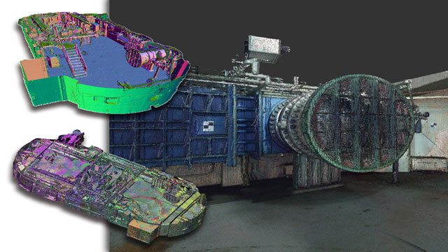
PMI was asked to participate in a pump station renovation in which asset and building life cycle management were high priority. Capturing post demolition conditions with terrestrial laser scanning assisted with the design process, and scanning final construction validated construction, graduating the design documents to as record drawing relevant for management of the building life cycle. The record drawings feature asset data such as model information and serial numbers for major equipment, key information for maintenance and repair.
Use case
Reality Capture + Asset Information Modeling
Manufacturing, Factory, Production Plant
PMI was asked to participate in a pump station renovation in which asset and building life cycle management were high priority. Capturing post demolition conditions with terrestrial laser scanning assisted with the design process, and scanning final construction validated construction, graduating the design documents to as record drawing relevant for management of the building life cycle. The record drawings feature asset data such as model information and serial numbers for major equipment, key information for maintenance and repair.
LiDAR, which stands for Light Detection and Ranging, is a remote sensing technology that uses laser light to measure distances to targets. By emitting laser pulses and analyzing the time it takes for the light to return, LiDAR systems can create highly accurate, three-dimensional maps of the environment. This technology is commonly used in applications such as topographic mapping, forestry, environmental monitoring, and autonomous vehicles. The precision and detail provided by LiDAR enable better decision-making and analysis in various fields, making it an essential tool for many industries.
LiDAR technology operates by emitting laser pulses from a sensor towards the ground and measuring the time it takes for the light to return after hitting an object. This process allows for the calculation of distances, which in turn helps create precise, three-dimensional maps of the surveyed area. The collected data is then processed to generate detailed topographical models, capturing features such as vegetation, buildings, and terrain. The system typically consists of a laser source, a GPS receiver, and an inertial measurement unit (IMU). The GPS provides accurate positioning, while the IMU helps maintain orientation during flight or movement. This combination enables the creation of high-resolution, accurate spatial data that is invaluable for various applications, including agriculture, forestry, urban planning, and environmental monitoring.
LiDAR technology has a wide range of applications across various industries. In the field of **topographic mapping**, it provides precise elevation data, enabling the creation of detailed digital elevation models. This is crucial for urban planning, flood modeling, and environmental studies. Another significant application is in **forestry management**. LiDAR is used to assess forest canopy height, biomass, and overall health, aiding in sustainable resource management. Additionally, in **autonomous vehicles**, LiDAR plays a vital role in mapping surroundings and detecting obstacles, enhancing navigation and safety. Its versatility also extends to **archaeology**, where it reveals buried structures and landscapes without disturbing the soil.
1. High Precision and Accuracy
LiDAR technology provides highly accurate topographical data, allowing for precise measurements of distances and elevations. This level of detail is beneficial in applications such as surveying, where accuracy is critical for planning and development.
2. Rapid Data Collection
The ability to capture large amounts of data quickly sets LiDAR apart from traditional methods. This efficiency reduces project timelines significantly, enabling faster decision-making and resource allocation.
3. Versatility in Applications
LiDAR is adaptable for various industries, including forestry, agriculture, and urban planning. Its ability to penetrate vegetation and provide ground surface data makes it invaluable for environmental assessments and land management.
4. 3D Modeling Capabilities
The technology enables the creation of detailed 3D models of landscapes and structures. These models enhance visualization and analysis, allowing stakeholders to better understand spatial relationships and design considerations.
5. Improved Safety
Using LiDAR reduces the need for personnel to enter hazardous areas, as data can be collected remotely. This minimizes risks associated with surveying in dangerous environments, thereby increasing overall safety for workers.
LiDAR technology is known for its exceptional accuracy in mapping and surveying applications. It can achieve vertical accuracy within 1 to 10 centimeters, depending on the system and environmental conditions. This level of precision is crucial for creating high-resolution topographic maps and conducting detailed surveys. Additionally, the horizontal accuracy of LiDAR can be within 10 to 30 centimeters. Factors such as the density of laser points, the calibration of the equipment, and the specific algorithms used for data processing all contribute to the overall accuracy. As a result, LiDAR is widely used in various fields, including forestry, urban planning, and environmental monitoring, where precise measurements are essential.
Some interesting numbers and facts about your company results for LiDAR
| Country with most fitting companies | United States |
| Amount of fitting manufacturers | 9865 |
| Amount of suitable service providers | 8370 |
| Average amount of employees | 11-50 |
| Oldest suiting company | 2004 |
| Youngest suiting company | 2021 |
20%
40%
60%
80%
Some interesting questions that has been asked about the results you have just received for LiDAR
What are related technologies to LiDAR?
Based on our calculations related technologies to LiDAR are Magnets, Printed Electronics, Industrial Amplifiers, Electronic Transducers, Electronic Oscillators
Who are Start-Ups in the field of LiDAR?
Start-Ups who are working in LiDAR are LiDAR PERU
Which industries are mostly working on LiDAR?
The most represented industries which are working in LiDAR are IT, Software and Services, Other, Construction, Electronics and Electrical engineering, Aviation and Aerospace
How does ensun find these LiDAR Companies?
ensun uses an advanced search and ranking system capable of sifting through millions of companies and hundreds of millions of products and services to identify suitable matches. This is achieved by leveraging cutting-edge technologies, including Artificial Intelligence.