Locations
Company type
Result types
Industries
Employees
Founding year

The B2B platform for the best purchasing descision. Identify and compare relevant B2B manufacturers, suppliers and retailers
Close
Filter
Result configuration
Continents
Select continent
Locations
Result types
Company type
Select company type
Industries
Select industry
Company status
Select company status preset
Number of employees
Min.
Max.
Founding year
Scan Survey AS
Oslo, Norway
A
11-50 Employees
1989
Key takeaway
Scan Survey offers comprehensive drone mapping services, including terrain modeling and detailed surveying using RPAS/drone technology. Their expertise extends to applications in construction projects and land reclamation, making them a valuable resource for accurate data collection and engineering assessments.
Reference
Service
Mapping and Measuring by RPAS/Drone - Scan Survey
Scan Survey As offers mapping and modelling via RPAS / drone over construction sites, landfills / land reclamation, etc for mass calculations or engineering.
Hawkeye
Bjørnafjorden, Norway
A
1-10 Employees
2014
Key takeaway
Hawkeye AS is an approved RO3 operator with extensive experience in aerial mapping, 3D laser scanning, and drone operations since 2014. They offer comprehensive drone mapping services, including orthophotos, 3D modeling, and inspection, making their data ideal for "AS BUILT" documentation and project planning.
Reference
Core business
Hawkeye AS - drone, 3d laser skann, mobile mapping, rådgiving, geomatikk
SCANDINAVIAN DRONE
Bergen, Norway
A
1-10 Employees
2016
Key takeaway
Scandinavian Drone AS offers comprehensive drone solutions, including the new YellowScan batymetric LiDAR system, specifically designed for capturing accurate images for photogrammetric modeling. Their focus on industrial applications highlights their expertise in using drones for mapping and inspection.
Reference
Core business
Scandinavian Drone AS - Industrielle droneløsninger
Scandinavian Drone AS leverer komplette droneløsninger for bedrifter som bruker droner for blant annet inspeksjon, dokumentasjon og kartlegging..
Looking for more accurate results?
Find the right companies for free by entering your custom query!
25M+ companies
250M+ products
Free to use
Buraq GeoServices
Drammen, Norway
A
1-10 Employees
2019
Key takeaway
Buraq GeoServices offers drone-based mapping and surveying services in Pakistan and Norway, emphasizing efficient and cost-effective data collection from the sky. Their commitment to safe operations and reliable data delivery enables clients to make informed decisions about critical assets.
Reference
Core business
Buraq Geo Services
Drone Services Company working All over Pakistan
Scout Drone Inspection
Trondheim, Norway
A
11-50 Employees
2017
Key takeaway
The company, ScoutDI, offers a tethered drone system that enables unlimited flight time for stress-free inspections, making it ideal for comprehensive drone mapping. Their Scout Portal enhances data management with features for live streaming, storage, and analysis of inspection data.
Reference
Core business
ScoutDI Indoor Inspection Drone — ScoutDI
Scout 137 indoor inspection drone for sale, unlimited flight-time and with 3D Lidar for navigation, anti-collision and location-tagged data.
ProXpect Drones AS
Lier, Norway
A
1-10 Employees
2021
Key takeaway
Droneteknologi has revolutionized property monitoring and maintenance, offering unique opportunities to enhance efficiency and reduce costs through drone mapping. Their advanced machine vision algorithms provide deep insights into property conditions, enabling quick and effective identification of issues, which optimizes overall management performance.
Reference
Product
Løsninger | Proxpect Drones
Geograf Digital AS
Stavanger, Norway
A
11-50 Employees
1996
Key takeaway
Geograf Digital AS is focused on setting the standard for digitalization in the construction industry through various technologies, including drones. They offer comprehensive solutions for creating digital twins, leveraging their expertise in GIS, photogrammetry, and 3D scanning to enhance data collection and reduce risks in construction projects.
Reference
Core business
Geograf Digital - Vi digitaliserer byggebransjen
Geograf Digital setter standarder for digitalisering i byggebransjen ved hjelp av ulike teknologier som drone, NavVis, laser, GPR og landseismikk.
Robot Aviation AS
Hønefoss, Norway
A
1-10 Employees
2008
Key takeaway
Robot Aviation is leading the way in autonomous aviation with its advanced drones designed for various applications, including environmental monitoring and infrastructure inspection. Their innovative use of robotics and artificial intelligence positions them as key players in transforming aerial interactions.
Reference
Core business
new-world-map - Robot Aviation
new-world-map %
KVS Technologies
Stavanger, Norway
A
11-50 Employees
2015
Key takeaway
Field is a geospatial technology company that utilizes drones equipped with high-resolution lidar and cameras to capture detailed images, making them well-suited for drone mapping applications. Their commitment to advanced technology and expertise ensures accurate and timely delivery of geospatial information.
Reference
Service
Corridor inspection - Field
Our drones are equipped with high-resolution lidar and cameras and advanced navigation systems, which allow them to capture detailed images of the area...

Skymedia AS
Oslo, Norway
A
- Employees
2016
Key takeaway
Skymedia AS specializes in high-quality drone mapping, offering services that include drone photography and video for architects, property developers, and visualizers. Their certified drone pilots ensure effective results, making them a preferred provider for aerial inspections and visual documentation.
Reference
Core business
Dronefoto til arkitekt, næring og eiendom | Skymedia AS
Er du næringsmegler, utbygger eller bedriftseier? Vi tilbyr dronefoto, fasadefoto og dronefilm til bruk ved transaksjon, dokumentasjon og visualisering.
Technologies which have been searched by others and may be interesting for you:
A selection of suitable products and services provided by verified companies according to your search.
Service
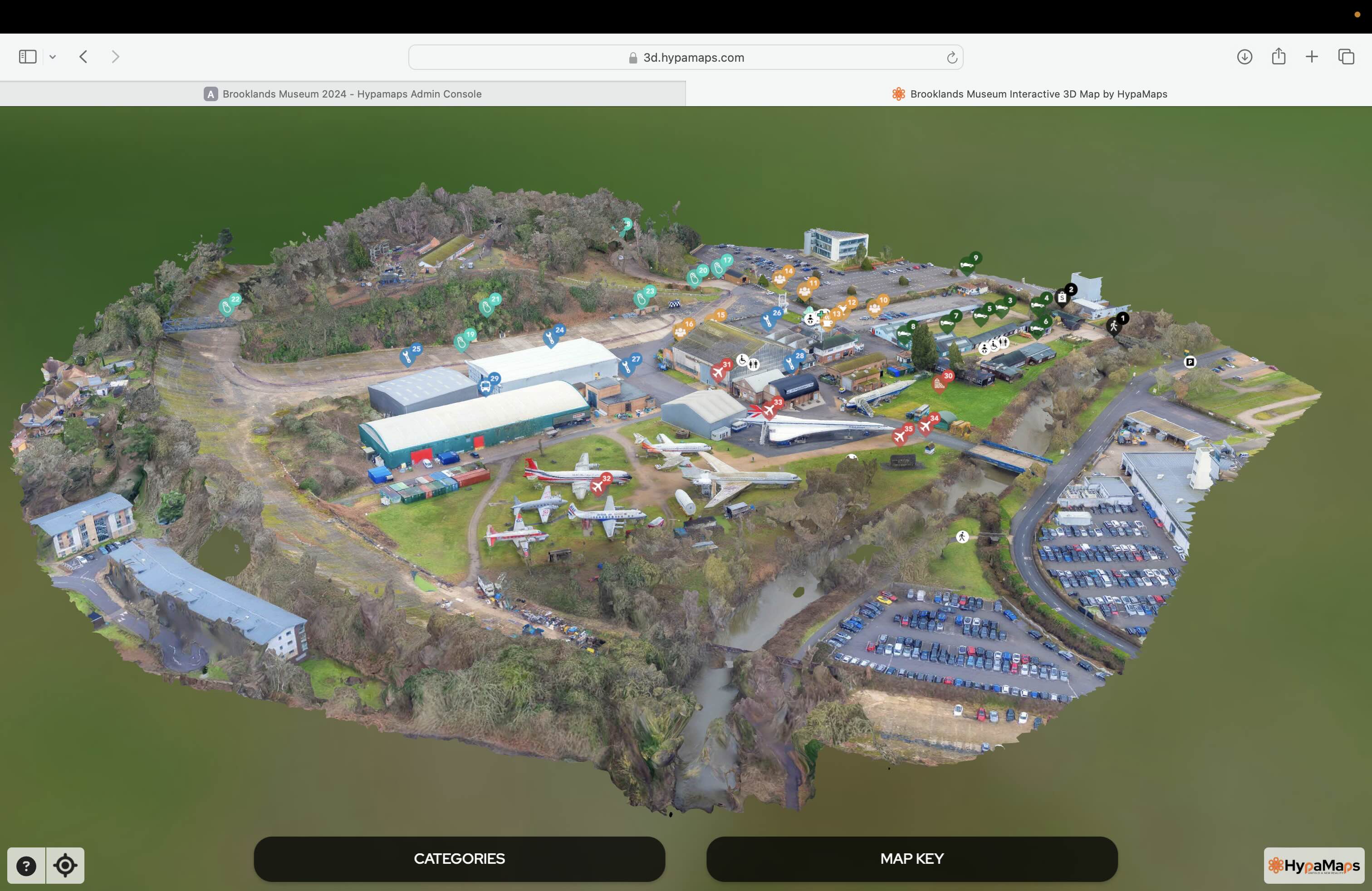
Interactive 3d Maps
Go to product
Service
Aerial Drone Photography and Inspection
Go to product
A selection of suitable use cases for products or services provided by verified companies according to your search.
Use case
Aerial Video and Photography
Ortophotography, Aerial Mapping, Real Estate, Advertising, Marketing, Sports, Corporate Marketing, Construction
Serviços que podemos oferecer: Inspeções a estruturas e edifícios, telhados, instalações industriais, antenas de comunicação, cabos de alta tensão ou redes eléctricas suspensas. Mapeamento aéreo de terrenos, infraestruturas ou pontos de interesse. Ánalise detalhada de pequenas e grandes áreas com alto nível de resolução espacial. Captação de imagens aéreas para o sector dos transportes e mobilidade urbana. Estaleiros e infraestruturas navais, sistemas ferroviários e rodoviários. Imagens aéreas para o sector do turismo e hotelaria; hotéis, resorts turísticos, alojamentos locais, pontos de interesse turísticos ou eventos relacionados. Captação e cobertura de eventos relacionados com a arte e cultura; concertos ou festivais, arte urbana ou exposições interiores ou ao ar livre. Captação de imagens para eventos desportivos, promoção de eventos e associações desportivas ou infraestruturas relacionadas com o desporto.
When exploring the drone mapping industry in Norway, several key considerations come into play. First, understanding the regulatory framework is crucial, as Norway has strict aviation laws governed by the Norwegian Civil Aviation Authority. These regulations dictate where and how drones can be operated, especially in urban areas and near airports, which can impact project planning and execution. Environmental concerns are also significant; Norway's diverse landscapes and wildlife require adherence to specific guidelines to minimize ecological impact. Challenges such as weather conditions, including harsh winters and varying visibility, can affect drone operations and data collection reliability. Opportunities abound in sectors like agriculture, forestry, and construction, where drone mapping can enhance efficiency and accuracy. The competitive landscape includes both local startups and established companies, necessitating thorough research into service quality, technology used, and pricing structures. Global market relevance is another factor to consider, as the demand for drone mapping services continues to grow worldwide. This trend presents both opportunities for collaboration and competition, making it essential to stay informed about international advancements and innovations in drone technology. Overall, a comprehensive understanding of these aspects will aid anyone interested in entering Norway's drone mapping sector.
Some interesting numbers and facts about your company results for Drone Mapping
| Country with most fitting companies | Norway |
| Amount of fitting manufacturers | 57 |
| Amount of suitable service providers | 43 |
| Average amount of employees | 11-50 |
| Oldest suiting company | 1989 |
| Youngest suiting company | 2021 |
Some interesting questions that has been asked about the results you have just received for Drone Mapping
What are related technologies to Drone Mapping?
Based on our calculations related technologies to Drone Mapping are Big Data, E-Health, Retail Tech, Artificial Intelligence & Machine Learning, E-Commerce
Who are Start-Ups in the field of Drone Mapping?
Start-Ups who are working in Drone Mapping are ProXpect Drones AS
Which industries are mostly working on Drone Mapping?
The most represented industries which are working in Drone Mapping are IT, Software and Services, Other, Oil, Energy and Gas, Aviation and Aerospace, Construction
How does ensun find these Drone Mapping Companies?
ensun uses an advanced search and ranking system capable of sifting through millions of companies and hundreds of millions of products and services to identify suitable matches. This is achieved by leveraging cutting-edge technologies, including Artificial Intelligence.