Locations
Company type
Result types
Industries
Employees
Founding year

The B2B platform for the best purchasing descision. Identify and compare relevant B2B manufacturers, suppliers and retailers
Close
Filter
Result configuration
Continents
Select continent
Locations
Result types
Company type
Select company type
Industries
Select industry
Company status
Select company status preset
Number of employees
Min.
Max.
Founding year

CERVI ROBOTICS SP Z O O
Jasionka, Poland
B
- Employees
2015
Key takeaway
Dronehub is revolutionizing drone operations with its autonomous drone-in-a-box solution, designed for continuous, on-demand aerial data collection. This capability significantly enhances monitoring and inspection processes, making it ideal for industries like oil and gas, security, and more.
Reference
Core business
Autonomous Drones In a Box | Dronehub – Digital transformation of your industry with autonomous drones in the box
AMI Systems
Gdynia, Poland
B
1-10 Employees
2020
Key takeaway
The company emphasizes the advantages of UAV LiDAR over traditional photogrammetry, particularly for mapping densely vegetated areas and forests, and highlights its capability to provide accurate digital terrain models essential for construction and surveying. With advanced technologies like SLAM algorithms and multi-vehicle 360° LiDAR systems, they offer efficient solutions for acquiring high-quality 3D data across various applications, including urban mapping and civil engineering.
Reference
Core business
AMI Systems – Your partner in tomorrows surveying needs
Book a live demo or submit a pilot project and find the best LiDAR system & data post-processing solution for your business! Grow your business with multi-vehicle 360° LiDAR systems Aerial and ground mobile LiDAR are revolutionizing surveying & BIM enabling industry professionals to efficiently acquire survey-grade accurate 3D data on small, medium, and large area &…
BIMdrone
Gliwice, Poland
B
1-10 Employees
-
Key takeaway
Bimdrone is a dedicated team of certified drone pilots and surveyors, emphasizing their expertise in engineering services and BIM technology. Their commitment to creativity and strong work values positions them as a reliable partner for innovative mapping solutions using drone technology.
Reference
Product
technology Archives - BIMdrone
Looking for more accurate results?
Find the right companies for free by entering your custom query!
25M+ companies
250M+ products
Free to use
DroneRadar
Warsaw, Poland
B
1-10 Employees
2015
Key takeaway
Droneradar is a key player in the drone mapping sector, supporting over 700,000 drone pilots through its integrated platform with PansaUTM. Their Droneradar mobile application, which is part of official training programs and has received certification for operational use, enhances the capabilities and safety of drone operations in Poland.
Reference
Core business
Droneradar · Fly wisely
KPGeo
Krakow, Poland
B
11-50 Employees
2012
Key takeaway
KPGeo specializes in providing professional data services, including a wide range of geospatial services such as aerial and terrestrial LiDAR products. Their expertise in high-accuracy LiDAR solutions could be particularly relevant for applications in drone mapping.
Reference
Product
LIDAR - KPGeo
SkySnap
Warsaw, Poland
B
1-10 Employees
2015
Key takeaway
The company specializes in providing accurate data from drones, helping professionals make better decisions and saving them hundreds of hours of work. Their drone mapping capabilities enable safe and non-invasive data collection and infrastructure inspection in hard-to-reach areas.
Reference
Core business
SkySnap.pl - skysnap.pl
GeoPixel UAV
Warsaw, Poland
B
1-10 Employees
2015
Key takeaway
The company is developing an innovative water sampling platform that utilizes drones to collect water samples from various depths in different water bodies. They also offer drone-based measurements, including photogrammetry, inspections, and bathymetry, highlighting their expertise in drone mapping and surveying.
Reference
Core business
USV GeoPixel / DRONY UAV USV ROV dla geodezji oraz batymetrii, pomiary dronem – Naloty fotogrametryczne, pomiary dronami UAV USV ROV, pomiary batymetryczne, budowa dronów na zamówienie.
Orbify
Krakow, Poland
B
1-10 Employees
2021
Key takeaway
Orbify leverages high-resolution satellite imagery to provide insightful data that can enhance decision-making for projects like urban planning. Their user-friendly platform simplifies access to remote sensing data and analytical tools, enabling users to quickly assess environmental conditions and monitor natural assets.
Reference
Core business
Geospatial Data Platform for Natural Assets Monitoring | Orbify
Easily access ready-to-use remote sensing data analysis using cutting-edge ML models. Designed for Nature-based Solutions (NbS), ESG & Sustainable Development Goals.
FLOTA 3D
Poland
B
11-50 Employees
-
Key takeaway
The company offers drone mapping services that include the acquisition of data using unmanned aerial vehicles (UAVs), generating various photogrammetric products such as orthophotos, models, and point clouds. They also provide advanced data processing, utilizing techniques like LiDAR and UAV photogrammetry to create professional spatial imagery.
Reference
Core business
Flota 3D – Skanowanie laserowe 3D – Fotogrametria UAV – Lidar
Zajmujemy się tworzeniem profesjonalnych zobrazowań przestrzennych przy wykorzystaniu technik fotogrametrii naziemnej i lotniczej.
FlyFocus
Warsaw, Poland
B
1-10 Employees
2017
Key takeaway
The company specializes in the design and production of unmanned aerial vehicles (UAVs) for various applications, including civilian, military, and law enforcement. Their expertise in UAV technology and custom engineering services highlights their capability in advanced aerial solutions.
Reference
Product
Portfolio - FlyFocus - our drones, your safety
Technologies which have been searched by others and may be interesting for you:
A selection of suitable products and services provided by verified companies according to your search.
Service
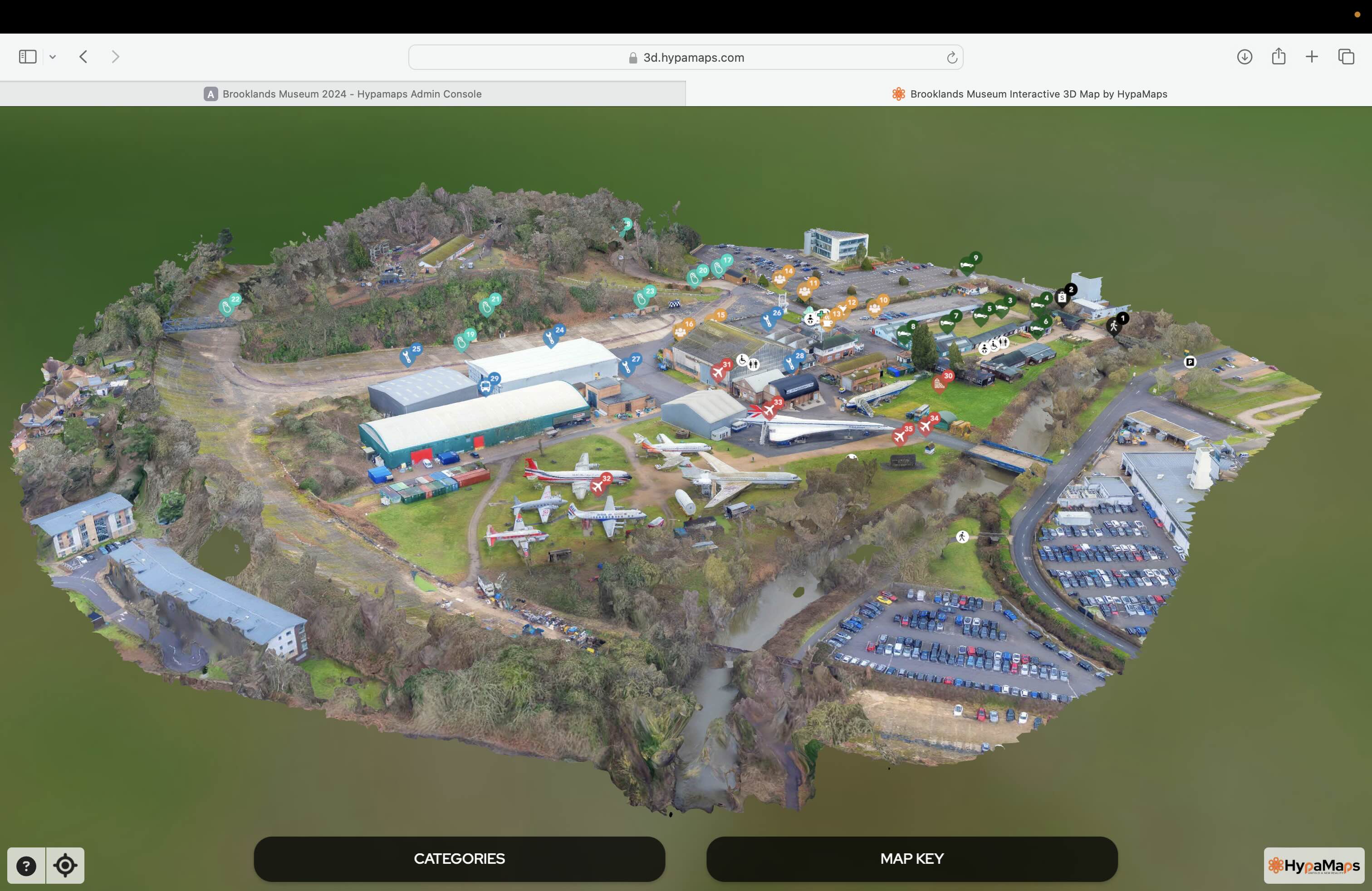
Interactive 3d Maps
Go to product
Service
Aerial Drone Photography and Inspection
Go to product
A selection of suitable use cases for products or services provided by verified companies according to your search.
Use case
Aerial Video and Photography
Ortophotography, Aerial Mapping, Real Estate, Advertising, Marketing, Sports, Corporate Marketing, Construction
Serviços que podemos oferecer: Inspeções a estruturas e edifícios, telhados, instalações industriais, antenas de comunicação, cabos de alta tensão ou redes eléctricas suspensas. Mapeamento aéreo de terrenos, infraestruturas ou pontos de interesse. Ánalise detalhada de pequenas e grandes áreas com alto nível de resolução espacial. Captação de imagens aéreas para o sector dos transportes e mobilidade urbana. Estaleiros e infraestruturas navais, sistemas ferroviários e rodoviários. Imagens aéreas para o sector do turismo e hotelaria; hotéis, resorts turísticos, alojamentos locais, pontos de interesse turísticos ou eventos relacionados. Captação e cobertura de eventos relacionados com a arte e cultura; concertos ou festivais, arte urbana ou exposições interiores ou ao ar livre. Captação de imagens para eventos desportivos, promoção de eventos e associações desportivas ou infraestruturas relacionadas com o desporto.
When exploring the Drone Mapping industry in Poland, several key considerations come into play. Firstly, regulations governing drone operations are crucial; the European Union Aviation Safety Agency (EASA) sets strict guidelines for drone usage, including licensing and operational limits that must be adhered to. Understanding these regulations can significantly impact business operations and compliance. The competitive landscape in Poland features a mix of established companies and startups, creating both challenges and opportunities. Companies should assess the technological capabilities and service offerings of competitors to identify potential niches or innovative solutions. Environmental concerns also play a role, as drone mapping can affect wildlife and ecosystems. Thus, sustainable practices are becoming increasingly important. Moreover, the global market for drone mapping is expanding, driven by advancements in technology and growing demand across various sectors such as agriculture, construction, and urban planning. This trend presents opportunities for Polish companies to tap into international markets and collaborate on cross-border projects. Finally, potential challenges such as high initial investment costs and the need for skilled personnel should be considered when evaluating the viability of entering this industry. Overall, awareness of these factors can provide valuable insights for anyone interested in the drone mapping sector in Poland.
Some interesting numbers and facts about your company results for Drone Mapping
| Country with most fitting companies | Poland |
| Amount of fitting manufacturers | 51 |
| Amount of suitable service providers | 45 |
| Average amount of employees | 1-10 |
| Oldest suiting company | 2012 |
| Youngest suiting company | 2021 |
Some interesting questions that has been asked about the results you have just received for Drone Mapping
What are related technologies to Drone Mapping?
Based on our calculations related technologies to Drone Mapping are Big Data, E-Health, Retail Tech, Artificial Intelligence & Machine Learning, E-Commerce
Who are Start-Ups in the field of Drone Mapping?
Start-Ups who are working in Drone Mapping are Orbify
Which industries are mostly working on Drone Mapping?
The most represented industries which are working in Drone Mapping are IT, Software and Services, Aviation and Aerospace, Other, Construction, Architecture and Planning
How does ensun find these Drone Mapping Companies?
ensun uses an advanced search and ranking system capable of sifting through millions of companies and hundreds of millions of products and services to identify suitable matches. This is achieved by leveraging cutting-edge technologies, including Artificial Intelligence.