Locations
Company type
Result types
Industries
Employees
Founding year

The B2B platform for the best purchasing descision. Identify and compare relevant B2B manufacturers, suppliers and retailers
Close
Filter
Result configuration
Continents
Select continent
Locations
Result types
Company type
Select company type
Industries
Select industry
Company status
Select company status preset
Number of employees
Min.
Max.
Founding year
GiantDrone
Seoul, South Korea
A
1-10 Employees
2015
Key takeaway
Giantdrone Co., Ltd is at the forefront of drone technology, offering high-accuracy survey information through their multi-purpose commercial drones, which are designed to suppress vibration during flight.
Reference
Product
Drone Surveying – Giant Drone Korea
SISTech Co. Ltd.
Seoul, South Korea
A
1-10 Employees
2021
Key takeaway
SISTech offers AI-powered 3D mapping solutions that utilize advanced cloud photogrammetry to create accurate models of real-world objects from photos, enhancing operational efficiency and providing clients with a competitive edge. Their innovative approach to mapping and data analysis is particularly beneficial for sectors requiring precise monitoring and planning.
Reference
Product
AI-Powered 3D mapping
3D Mapping is a technique to obtain reliable data of real-world objects in the environment by creating 3D models from photos.
Beamo
Seoul, South Korea
A
51-100 Employees
2017
Key takeaway
Beamo offers a 360° photo-based digital twin solution that allows for easy site capture and immediate generation of a 360 view, making it an effective tool for mapping and visualizing spaces. With automated picture positioning and the ability to create digital twins using just a 360-camera, smartphone, and tripod, Beamo facilitates precise mapping even in areas without GPS.
Reference
Core business
Beamo - Connecting people & places
Beamo is an enterprise-grade digital twin solution for mission-critical facilities and remote sites. Capture, augment, collaborate in 360°.
Looking for more accurate results?
Find the right companies for free by entering your custom query!
25M+ companies
250M+ products
Free to use
Vueron
Seoul, South Korea
A
11-50 Employees
2019
Key takeaway
Vueron focuses on enhancing safety through its innovative LiDAR solutions, which incorporate artificial intelligence and embedded systems. Their technology is designed to transform how we understand and engage with our environment, making it particularly relevant for applications like drone mapping.
Reference
Product
Lidar Solution with AI, Embeded System and Platform | VUERON Lidar Technology
Vueron’s Lidar solution with AI, Embeded system and Platform poised to redefine how we perceive and interact with the world.
InSpace
Daejeon, South Korea
A
- Employees
2012
Key takeaway
HANCOM InSpace leverages innovative technologies and unique intellectual property to enhance satellite and drone operations. Their expertise in processing satellite images and providing unmanned drone operation platforms positions them well in the growing market for advanced mapping solutions.
Reference
Core business
한컴인스페이스 | HANCOM InSPACE | GEOINT | South Korea | (주)한컴인스페이스
GEOINT Solutions Satellite/UAV ground platform Deep learning HANCOM InSpace: Intelligence in Space DroneSAT platform South Korea
fabWeaver
Seoul, South Korea
A
1001-5000 Employees
2021
Key takeaway
The company, fabWeaver, emphasizes its advanced technology and precision in 3D printing, offering a comprehensive platform that includes end-to-end solutions and services related to the 3D printing process. Their focus on optimizing workflow and reducing inefficiencies could be relevant for applications like drone mapping that require high-quality, precise printouts.
Reference
Product
Weaver3 Cloud & Mobile, 3D Printer Cloud Solution to managing 3D printing Workflow virtually anywhere | fabWeaver
Vorasky
Seoul, South Korea
A
11-50 Employees
2016
Key takeaway
VORASKY is a specialized manufacturer of high-performance drones, focusing on the development and production of customized unmanned aerial vehicles (UAVs) using 100% in-house technology. Their expertise in robotics and aerodynamics enables them to push the limits of industrial drone performance, making them a key player in the drone mapping sector.
Reference
Core business
특수목적드론 | Vorasky Drone | 서울특별시
VORASKY는 1세대 로보틱스 기술진들이 주축이 되어 설립된 초고성능 맞춤형 드론 전문제조 기업입니다.
Cygbot
Seoul, South Korea
A
1-10 Employees
-
Key takeaway
Cygbot specializes in advanced 3D environment recognition through its innovative LiDAR camera technology, which can be effectively utilized in various applications, including autonomous driving and robotics. Their product line emphasizes safety and efficiency, making it a valuable resource for drone mapping and related technologies.
Reference
Core business
Cygbot
Solid State LiDAR , 2D/3D Dual ToF LiDAR, Robotics, Autonomous driving, 3D Camera, https://www.cygbot.com

Navis Automotive Systems, Inc.
Busan, South Korea
A
251-500 Employees
2005
Key takeaway
Navis Automotive Systems provides high-definition 3D maps that enhance navigation and driving experiences, which could be relevant for applications in drone mapping. Their expertise in creating customized navigation solutions for various automotive models underscores their capability in delivering accurate and realistic mapping data.
Reference
Core business
Navis Automotive Systems
Convenient, safely and reliable driveways Navis Automotive Systems
FM Inc
Cheongju-si, South Korea
A
51-100 Employees
2002
Key takeaway
FM Inc. aims to enhance the potential of its members and promote cultural and artistic development through the use of LiDAR technology, which is instrumental in drone mapping and creating 3D models.
Reference
Core business
FM | LiDAR
FM Inc.는 구성원들의 잠재력 향상과 더불어 문화 예술의 발전을 위해 라이다 센서라는 전세계에서 각광 받는 기술을 바탕으로 기술과 예술이 소통하는 사회를 만드는 것을 목표로 하고 있습니다.
Technologies which have been searched by others and may be interesting for you:
A selection of suitable products and services provided by verified companies according to your search.
Service
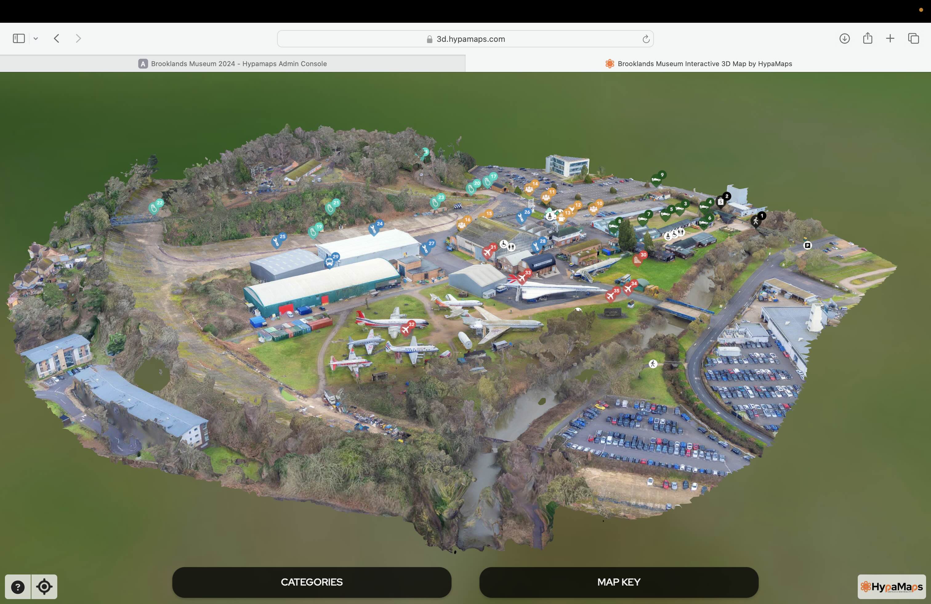
Interactive 3d Maps
Go to product
Service
Aerial Drone Photography and Inspection
Go to product
A selection of suitable use cases for products or services provided by verified companies according to your search.
Use case
Aerial Video and Photography
Ortophotography, Aerial Mapping, Real Estate, Advertising, Marketing, Sports, Corporate Marketing, Construction
Serviços que podemos oferecer: Inspeções a estruturas e edifícios, telhados, instalações industriais, antenas de comunicação, cabos de alta tensão ou redes eléctricas suspensas. Mapeamento aéreo de terrenos, infraestruturas ou pontos de interesse. Ánalise detalhada de pequenas e grandes áreas com alto nível de resolução espacial. Captação de imagens aéreas para o sector dos transportes e mobilidade urbana. Estaleiros e infraestruturas navais, sistemas ferroviários e rodoviários. Imagens aéreas para o sector do turismo e hotelaria; hotéis, resorts turísticos, alojamentos locais, pontos de interesse turísticos ou eventos relacionados. Captação e cobertura de eventos relacionados com a arte e cultura; concertos ou festivais, arte urbana ou exposições interiores ou ao ar livre. Captação de imagens para eventos desportivos, promoção de eventos e associações desportivas ou infraestruturas relacionadas com o desporto.
When exploring the Drone Mapping industry in South Korea, several key considerations emerge. The regulatory landscape is crucial, as the country has implemented stringent guidelines governing drone operations, including licensing requirements and no-fly zones, particularly near urban areas and critical infrastructure. Understanding these regulations is essential for compliance and operational success. Moreover, the competitive landscape is dynamic, with numerous local startups and established companies vying for market share. Collaborations with technology firms can enhance service offerings, particularly in areas like data processing and analytics. Environmental concerns are increasingly significant, as drone mapping can impact wildlife and ecosystems. Companies must adhere to sustainable practices to mitigate these effects. Additionally, the opportunities in sectors such as agriculture, construction, and mining are vast, driven by advancements in drone technology and data analytics. The global market relevance of South Korea is notable, given its strong emphasis on technological innovation and smart city initiatives, which further support the growth of drone mapping solutions. Overall, those interested in this industry must navigate regulatory frameworks, assess competitive dynamics, and prioritize environmental sustainability while capitalizing on emerging opportunities in various sectors.
Some interesting numbers and facts about your company results for Drone Mapping
| Country with most fitting companies | South Korea |
| Amount of fitting manufacturers | 11 |
| Amount of suitable service providers | 4 |
| Average amount of employees | 51-100 |
| Oldest suiting company | 2002 |
| Youngest suiting company | 2021 |
Some interesting questions that has been asked about the results you have just received for Drone Mapping
What are related technologies to Drone Mapping?
Based on our calculations related technologies to Drone Mapping are Big Data, E-Health, Retail Tech, Artificial Intelligence & Machine Learning, E-Commerce
Who are Start-Ups in the field of Drone Mapping?
Start-Ups who are working in Drone Mapping are SISTech Co. Ltd.
Which industries are mostly working on Drone Mapping?
The most represented industries which are working in Drone Mapping are IT, Software and Services, Other, Aviation and Aerospace, Electronics and Electrical engineering
How does ensun find these Drone Mapping Companies?
ensun uses an advanced search and ranking system capable of sifting through millions of companies and hundreds of millions of products and services to identify suitable matches. This is achieved by leveraging cutting-edge technologies, including Artificial Intelligence.